1. Executive Summary
During the reporting period of May 2 to May 9, 2026, the global operational landscape for military drones and autonomous vehicles experienced a convergence of intense kinetic engagements, rapid defense industrial base technological reveals, and fundamental doctrinal shifts across the air, land, sea, and space domains. The proliferation of low-cost, highly scalable uncrewed systems continues to dismantle traditional economic and operational paradigms of warfare, forcing established military powers to rapidly reassess force design, sustainment, and air defense architectures.
In the maritime domain, the Middle East witnessed a surge in autonomous and semi-autonomous threat vectors. The United States initiated Operation Project Freedom in the Strait of Hormuz to counter complex swarm attacks by Iranian forces—utilizing uncrewed aerial vehicles (UAVs) and fast attack boats—before temporarily pausing the operation amidst diplomatic negotiations.1 Simultaneously, Houthi forces in the Red Sea demonstrated an evolving reliance on uncrewed surface vessels (USVs) to target commercial shipping, highlighting the vulnerability of traditional naval radar systems in cluttered littoral environments.4
In the terrestrial and aerial domains of Eastern Europe, the Russo-Ukrainian conflict remains the primary catalyst for uncrewed systems innovation and mass deployment. The reporting period saw a massive escalation in deep-strike capabilities, culminating in a highly coordinated, 347-drone swarm launched by Ukrainian forces against Russian infrastructure ahead of Victory Day.6 This operation underscored the strategic maturation of extended-range systems, which are increasingly operating at distances and payload capacities traditionally reserved for strategic cruise missiles.7 Concurrently, a temporary, U.S.-brokered three-day ceasefire introduced a brief operational pause to the hyper-attritional environment, facilitating a prisoner exchange.8
Technological development pipelines across the global defense industrial base are heavily focused on overcoming the physical, cognitive, and electromagnetic limitations of current autonomous systems. The Defense Advanced Research Projects Agency (DARPA) and major defense contractors advanced initiatives aimed at breaking the standard 1:1 payload-to-weight ratio barrier for vertical-lift platforms, decentralizing swarm command and control to reduce human operator burdens, and integrating autonomous terminal homing capabilities to negate electronic warfare (EW) jamming.10 On the ground, the transition toward autonomous frontline sustainment accelerated with the advanced testing of armed Unmanned Ground Vehicles (UGVs) designed to traverse the highly contested “last tactical mile”.13
Furthermore, the operationalization of the space domain as a theater for dynamic maneuver warfare reached critical milestones. The U.S. Space Force signaled a doctrinal pivot toward maneuverable, refuelable satellites capable of orbital operations, supported by the continued mission of the X-37B spaceplane and newly awarded contracts for autonomous orbital servicing vehicles.14
This report synthesizes these multidomain developments, organizing the gathered open-source intelligence into a detailed global situation log, an exhaustive review of product advancements, an analysis of strategic lessons learned, and a combined chronological ledger that strictly orders all events and insights by date and primary country involved.
2. Global Situation Log
The following section details the kinetic engagements, military operations, and tactical deployments of unmanned systems across global theaters during the reporting period.
Air and Maritime Domains: Middle East Theater
The Middle East remains a highly volatile testing ground for asymmetric autonomous warfare, characterized by the deployment of massed, low-cost drone swarms against highly exquisite, traditional naval and air defense platforms.
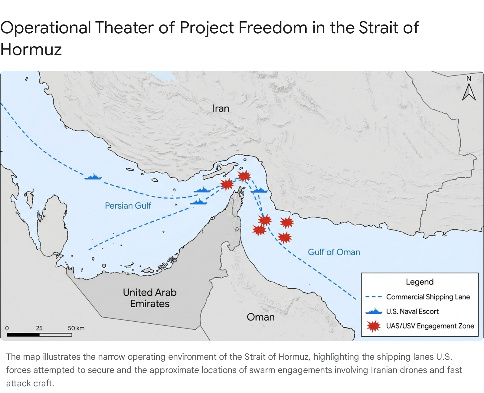
The U.S.-Israeli military campaign against Iran, designated Operation Epic Fury, officially concluded on May 5.17 This operation, which began in late February, had triggered massive retaliatory barrages of drones and missiles across the region, fundamentally disrupting maritime trade and regional stability. In immediate response to the ongoing threat to commercial shipping in the Persian Gulf and the Gulf of Oman, the U.S. Central Command initiated Operation Project Freedom on May 4.2 Designed as an active maritime escort initiative, the operation aimed to guide stranded commercial vessels through the strategically critical Strait of Hormuz, utilizing an “enhanced security area” established south of typical shipping routes to mitigate the risk of uncleared naval mines.18
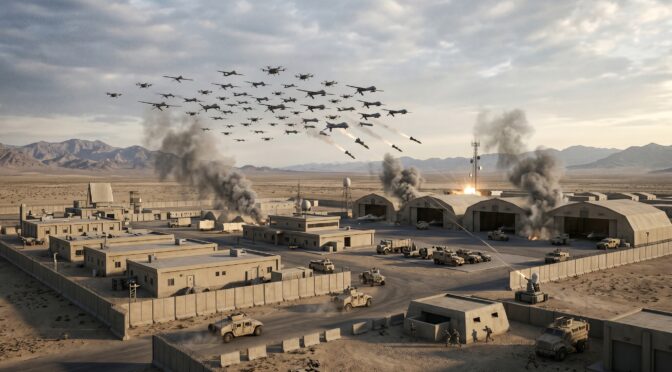
The operational environment during Project Freedom was characterized by immediate and aggressive responses from Iranian forces, which deployed a combination of anti-ship cruise missiles, UAVs, and fast attack boats.1 U.S. Navy destroyers, operating under a persistent threat umbrella, successfully intercepted incoming drone swarms using advanced layered air defense systems, supported by Air Force F-16s and Navy MH-60 Sea Hawk helicopters.19 Reports indicate that defensive engagements resulted in the sinking of at least seven Iranian small boats.2
On May 5, citing “great progress” in diplomatic negotiations mediated by third parties, U.S. leadership announced a temporary pause to Operation Project Freedom.3 Despite this pause, the underlying tensions regarding freedom of navigation remain unresolved. Iranian military command issued stark warnings that any unauthorized foreign military presence in the Strait of Hormuz would be targeted, maintaining a posture heavily reliant on asymmetric drone and missile deterrence.18 By May 9, localized kinetic engagements resumed, with Iranian naval and missile forces reportedly launching renewed attacks against U.S. warships operating near the shipping lanes, illustrating a persistent anti-access/area-denial (A2/AD) strategy intended to impose continuous tactical friction on U.S. naval operations.1
Concurrently, throughout the reporting period, Houthi forces in Yemen maintained their interdiction campaign in the Red Sea, demonstrating a notable tactical shift toward the employment of sophisticated USVs. In a prominent incident, a Houthi maritime drone struck the U.S.-linked oil tanker Chios Lion, a vessel carrying a full cargo of crude oil, raising severe environmental and maritime security concerns.5 The reliance on low-profile, explosive-laden USVs alongside one-way attack UAVs (OWA UAVs) presents a complex targeting challenge for traditional naval radar systems, which frequently struggle to distinguish these autonomous craft from sea clutter in the narrow, highly trafficked waters of the Bab el-Mandeb strait.5 This tactical evolution indicates that non-state actors are successfully integrating autonomous naval technologies to project disproportionate strategic influence over global maritime trade routes.
Air and Land Domains: Eastern European Theater
The operational tempo regarding uncrewed systems in the Russo-Ukrainian war reached unprecedented levels of scale and reach during the reporting period. The battlefield has evolved into a live environment of continuous military-technical experimentation, with both combatants leveraging drones for deep precision strikes, front-line attrition, and psychological warfare.7
On May 5, Russian forces executed a series of devastating strikes utilizing uncrewed systems and aerial bombs against Ukrainian industrial facilities, residential areas, and rescue infrastructure in Zaporizhzhia, Kramatorsk, and Poltava, resulting in multiple casualties.24 The Poltava engagement was particularly notable for its use of a “double-tap” tactic, wherein a secondary drone strike was specifically timed to hit first responders arriving at the scene of the initial impact.24 Furthermore, intelligence analysis indicates a strategic shift in Russian targeting methodologies; Moscow has increasingly coupled its traditional large-scale nighttime drone barrages with equally massive daytime strikes.25 This adaptation is designed to inflict greater disruption on civilian infrastructure and maximize harm during peak outdoor hours, representing a deliberate psychological escalation in the deployment of long-range attack drones. Data compiled by the Ukrainian Air Force indicated that Russia launched a record 6,583 long-range drones in April, marking a sustained upward trajectory in drone deployment volume.25
In response to sustained Russian aggression, Ukrainian forces demonstrated a massive escalation in deep-strike capabilities. On May 7, in one of the largest coordinated unmanned aerial assaults of the conflict, the Ukrainian military launched 347 long-range drones across 20 Russian regions.6 The timing of the strike was highly symbolic, occurring just prior to Russia’s annual Victory Day military parade. The operation targeted critical hydrocarbon production, storage, and export infrastructure, continuing a sustained campaign to degrade the economic engines funding the Russian war effort.26 Strikes were reported as far inland as the Leningrad Oblast, over 600 kilometers from the Ukrainian border, demonstrating the extended reach, payload capacity, and navigational resilience of domestically produced Ukrainian UAVs.26 The sheer density of the drone swarm effectively saturated Russian air defense networks, forcing the Kremlin to allocate strategic interceptors to protect deep-rear economic assets.
Amidst these escalating exchanges, a U.S.-brokered three-day ceasefire was announced on May 8, slated to run through May 11.9 The agreement included a suspension of all kinetic activity—including drone and missile strikes—and a mutual exchange of 1,000 prisoners of war from each country.27 While previous unilateral ceasefires in the conflict have rapidly unraveled due to deep-seated mistrust and near-immediate violations 8, this brief operational pause provided a critical window for both sides to reconstitute depleted drone stockpiles, repair damaged infrastructure, and reposition air defense assets. President Volodymyr Zelenskyy noted that Ukraine’s consent to the agreement was primarily driven by the prospect of freeing prisoners of war, while mockingly issuing a decree authorizing Russia to hold its Red Square parade free from Ukrainian drone strikes during the pause.8
3. Product Developments
The global defense industrial base generated substantial hardware, software, and doctrinal reveals during the reporting period. These developments span individual tactical payloads to highly complex, multi-domain autonomous systems, reflecting an urgent push to commercialize innovations born from current conflicts.
Autonomous Aerial Systems and Heavy-Lift Capabilities
A persistent limitation of current commercial and tactical vertical take-off and landing (VTOL) drones is their payload capacity. Existing Group 1-3 airborne platforms typically operate with a payload-to-weight ratio of approximately 1:1, severely restricting their utility for frontline resupply.10 To shatter this physical barrier,(https://www.darpa.mil/) progressed its “Lift Challenge,” officially closing applications in May ahead of live flight trials scheduled for August 2-9.10 The initiative incentivizes innovators to build a drone capable of lifting at least four times its weight (a 4:1 ratio). Program managers assess this exponential leap as plausible through the convergence of alternative aerodynamic designs, advanced computational modeling, novel materials science, and optimized open-source flight controllers.10
Concurrently, the U.S. Army advanced its procurement of specialized tactical UAVs designed to provide immediate capabilities to frontline units. The military announced a contract for the FUSE-developed THOR Group 2 UAS.29 The THOR system is a backpack-portable, fully autonomous VTOL multi-rotor platform designed to fulfill company-level requirements for reconnaissance, surveillance, target acquisition, and localized resupply. Simultaneously, the U.S. Army awarded a $5.2 million contract to Perennial Autonomy for the Bumblebee V2 counter-drone system.30 Designed as a low-cost kinetic interceptor, the Bumblebee functions as a next-generation first-person-view (FPV) multirotor that identifies, tracks, and neutralizes hostile unmanned systems through direct physical collision, rendering both the interceptor and the threat inoperable. The system has already seen semi-autonomous deployment in the Ukrainian theater.30
Larger autonomous strike platforms also saw significant testing. During the U.S. Army’s Operation Lethal Eagle, Northrop Grumman successfully demonstrated the combat viability of its new “Lumberjack” one-way attack drone.31 Introduced as an inexpensive, Group 3 platform capable of delivering kinetic and non-kinetic effects, the Lumberjack successfully executed simulated precision strikes against ground targets. Crucially, the platform integrated the Maven Smart System, allowing the drone to utilize artificial intelligence for adaptive, autonomous target detection without relying on continuous human piloting.31 The platform’s ability to be launched from modified, agnostic ground launchers highlights a broader military push toward highly distributed, platform-independent kinetic effectors.
At the upper echelon of aerial autonomy, the reporting period featured significant developments regarding the introduction of fully autonomous fighter jets designed for high-end combat. Defense startups Hermeus and Anduril are actively redefining air power paradigms.32 Anduril unveiled details regarding “Fury,” an AI-driven, pilotless fighter jet boasting lethal combat capabilities, which is scheduled for test flights and integration into the Air Force’s Collaborative Combat Aircraft (CCA) program.32 Similarly, the defense firm Helsing introduced the “CA-1,” an autonomous fighter jet equipped with the “Centaur AI agent,” which functions as an autonomous pilot capable of operating independently or within collaborative swarms alongside crewed aircraft.34 These platforms represent a transition from remotely piloted drones to fully autonomous combat wingmen.
Terrestrial Logistics and the “Last Tactical Mile”
The grinding, casualty-heavy realities of modern land operations have accelerated the demand for Unmanned Ground Vehicles (UGVs). The U.S. Army issued formal notices seeking autonomous UGVs specifically to traverse the “last tactical mile”—the highly dangerous, logistically complex segment separating support units from the forward line of troops.13 This operational space is currently saturated by persistent enemy surveillance and rapid lethal effects, making traditional manned resupply convoys highly vulnerable to FPV drones and artillery.13
To address this gap, the U.S. Army has been testing the armed Hunter Wolf UGV.36 This platform is designed to shape future frontline logistics and combat security roles, incorporating advanced armament configurations such as a 30mm cannon and Coyote Stinger missiles for localized counter-drone air defense.37 The integration of robust UGVs like the Hunter Wolf offers a dual capability: executing high-risk resupply and medical evacuation missions without exposing human drivers, while simultaneously providing organic kinetic defense against the very drone threats that make the environment lethal. Current U.S. Army UGV programs are being evaluated against the need for disposable or high-turnover logistics platforms, a lesson directly imported from the widespread use of low-cost UGVs by Ukrainian infantry brigades.35
Maritime and Space Domain Autonomy
In the maritime domain, AEVEX Corporation utilized the SOFweek conference in Tampa to conduct live harbor demonstrations of its Mako Lite Unmanned Surface Vehicle (USV).38Showcasing the platform alongside mission-tailored “launched effects” and Advanced Positioning, Navigation and Timing (A2PNT) solutions, AEVEX demonstrated capabilities specifically engineered for highly contested and GPS-denied littoral environments.38These commercial developments parallel the rapid procurement of autonomous maritime assets globally, such as Australia’s integration of the “Ghost Shark” autonomous undersea drone for persistent domain awareness.39
The space domain is undergoing a fundamental doctrinal shift toward dynamic, autonomous operations. Historically, military satellites operated in static orbits, rendering them vulnerable to emerging anti-satellite weapons. The U.S. Space Force’s 15-year Objective Force plan explicitly embraces orbital mobility, anticipating a quintupling of the global satellite fleet to 60,000 by 2040.40 To survive in a contested domain, satellites must possess the ability to maneuver dynamically—a capability that inherently expends finite fuel reserves.16
To facilitate this shift, the Space Force is heavily leveraging autonomous space vehicles. The Boeing-built X-37B Orbital Test Vehicle (OTV-8) surpassed 230 days in orbit, continuing to test advanced technologies and autonomous maneuverability while carrying experimental payloads such as materials exposure tests and seeds for deep-space missions.42 The platform provides an unrivaled capability to evaluate dynamic space operations and return hardware for inspection.43
Furthermore, the Space Force is actively investing in Space Access, Mobility and Logistics (SAML). Space Systems Command, via SpaceWERX, awarded a $37.5 million contract to Starfish Space to utilize its “Otter Pup” satellite.15 Scheduled for a 2026 logistics mission, the Otter spacecraft will perform autonomous rendezvous, proximity operations, and docking (RPOD) to service Space Force assets in Geostationary Earth Orbit (GEO), providing additional propulsion or extending the service life of satellites not originally designed for docking.15 This mission, alongside the planned Tetra-5 and Tetra-6 refueling demonstrations scheduled for 2026 and 2027, signifies the operationalization of orbital logistics necessary to sustain a maneuverable space force.45 Concurrently, the private sector maintained a rapid launch cadence, with SpaceX executing multiple Falcon 9 autonomous booster recoveries following the deployment of Starlink and National Reconnaissance Office (NRO) payloads from Vandenberg and Cape Canaveral Space Force Bases.46
Payloads, Software, and Industrial Base Convergence
The integration of advanced software and sub-systems is critical to scaling autonomous operations. At the XPONENTIAL 2026 conference and SOF Week, the defense industrial base showcased numerous solutions addressing current battlefield friction points:
- Terminal Homing and EW Resilience: A critical vulnerability of current FPV drones is the loss of control signals during terminal dive phases due to intense EW jamming. Teledyne FLIR addressed this with its “Mission-Autonomous Pixel Lock” architecture.12 By integrating Automated Target Recognition (ATR) directly onto the optical payload, the system allows operators to visually lock a target. The drone then autonomously guides itself to the designated pixel cluster, entirely severing its reliance on external RF command links or GPS, ensuring high lethality in contested electromagnetic environments.12
- Swarm C2 and Decentralized AI: Shield AI and Palantir announced the integration of the Hivemind technology into command-and-control interfaces.49 This integration allows operators to manage multiple uncrewed vehicles from a single platform, enabling drones to autonomously detect threats, coordinate targeting, and adapt missions without direct human piloting. This addresses the severe personnel bottlenecks currently limiting drone deployment.11
- Tactical Edge Forensics: As drones become ubiquitous, exploiting captured adversary platforms is vital. Cellebrite demonstrated edge-ready digital intelligence solutions, including the CFID system, which allows special operations forces to extract UAV data and visualize flight paths directly in the field, enabling rapid attribution and targeting of drone origin points without relying on centralized intelligence workflows.50
- BVLOS Connectivity: Domo Tactical Communications (DTC) launched the BluTrak-90-D autonomous tracking antenna.51 This self-contained, high-gain directional antenna automatically tracks moving drones, vastly improving signal strength and link stability for long-range ISR and commercial operations, while minimizing the probability of signal interception.52
- Additive Manufacturing: The capacity to produce drones rapidly is as critical as the technology itself. Unusual Machines, partnering with HP Additive Manufacturing Solutions, showcased deployment-ready drone ecosystems at XPONENTIAL, highlighting how 3D printing and localized production are essential for supply chain resilience and scaling autonomous fleets.53 AEVEX similarly highlighted its ForgeX additive manufacturing capability, demonstrating forward-relevant, rapid production concepts for austere environments.38
- MOSA Standards: Elma Electronic and other hardware providers emphasized the critical need for Modular Open Systems Approach (MOSA) standards, such as VITA 90 (VNX+), to future-proof uncrewed vehicles and optimize Size, Weight, and Power (SWaP) constraints, ensuring interoperability across disparate defense platforms.55
4. Strategic Lessons Learned
The application of autonomous systems in recent global conflicts has generated profound tactical, operational, and strategic lessons. These insights are actively reshaping future force design, procurement strategies, and economic models of defense.
The Economics of Asymmetric Warfare
A central reality of modern conflict, definitively proven in the Middle East and Ukraine, is that the proliferation of low-cost, highly scalable autonomous systems has fundamentally altered the economics of warfare.56 State actors and proxy forces have demonstrated the ability to deploy inexpensive drones—such as the $36,000 Shahed-136 kamikaze drone—at scale. This dynamic forces technologically advanced militaries to respond with vastly more expensive conventional interceptors and integrated air defense systems, such as the $4 million Patriot PAC-3 missile.56
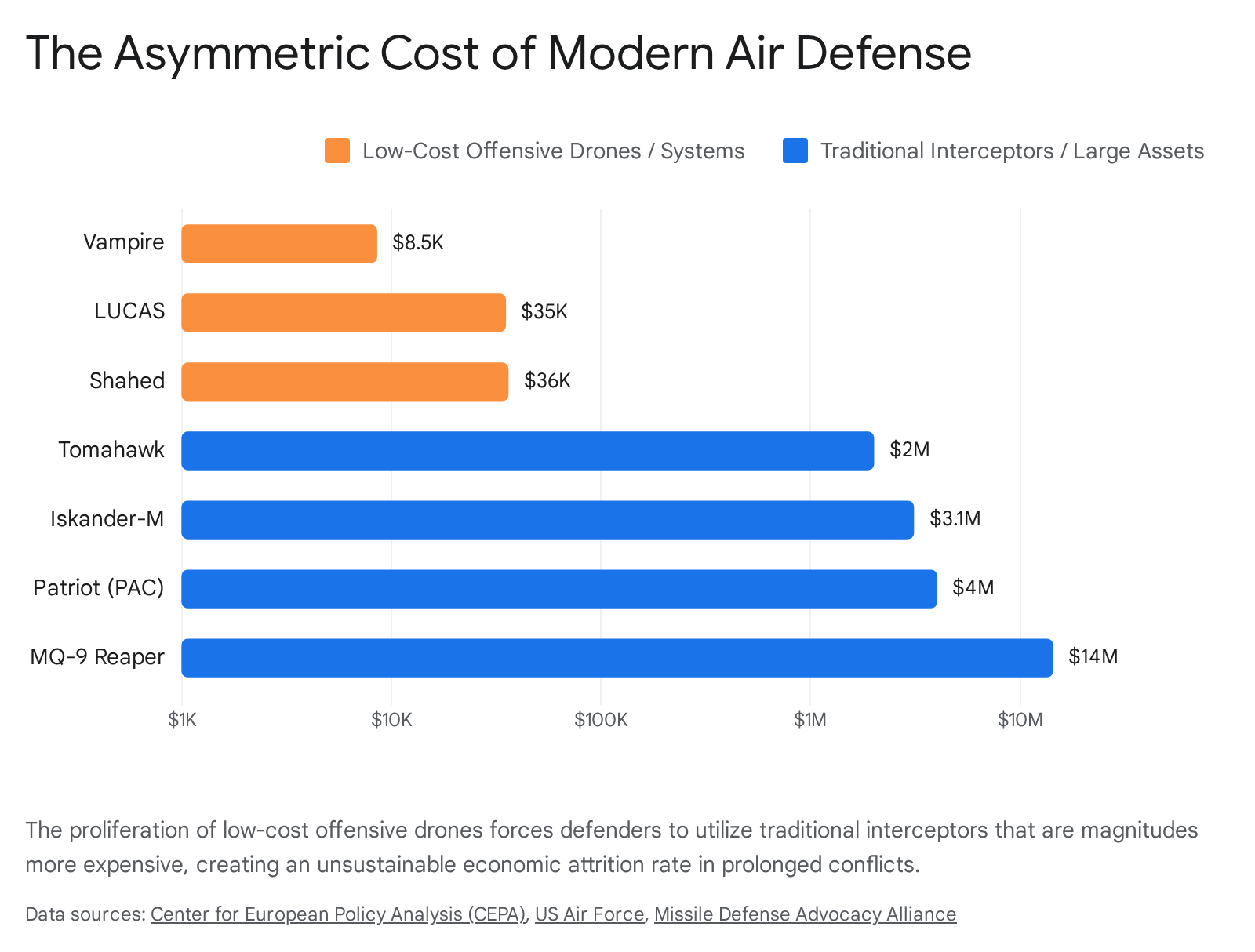
This cost-exchange ratio is entirely unsustainable over protracted engagements. It exhausts high-end munitions stockpiles and strains the defense industrial base’s capacity to replenish sophisticated interceptors. The strategic lesson learned is that allied forces must urgently transition away from relying solely on legacy air defense architectures. Superiority in future combat requires massive investments in directed energy weapons, advanced electronic warfare (EW) countermeasures, and equally inexpensive autonomous counter-UAS interceptor swarms to restore economic parity to defensive operations.56
Defeating the “Tyranny of Distance” via Autonomous Sustainment
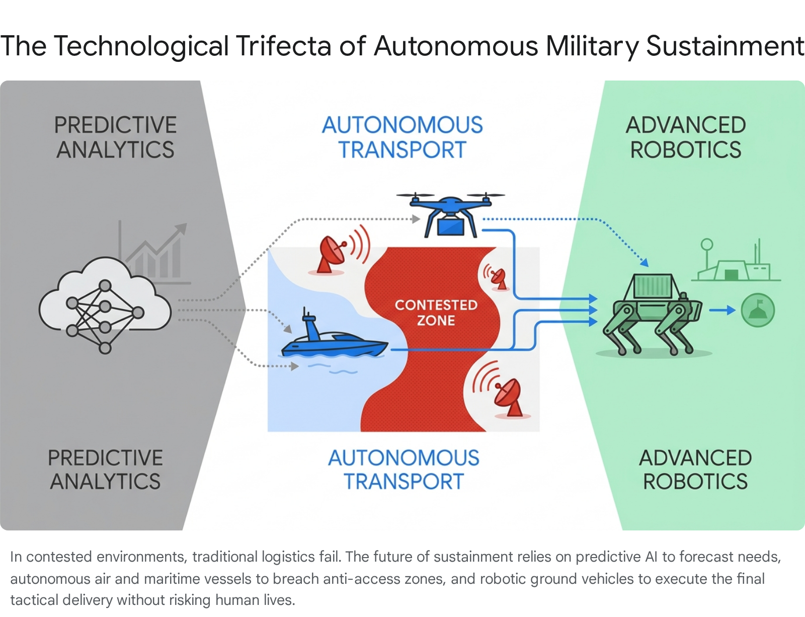
Logistical sustainment in expansive theaters, particularly the Indo-Pacific, is increasingly recognized as a critical vulnerability. An analysis by the Modern War Institute detailed a scenario in which forward-deployed elements, such as an air defense battery protecting an isolated island chain, face culmination not from direct enemy fire, but from the inability of traditional assets to penetrate adversary A2/AD zones.57 Traditional resupply methods, such as vulnerable C-130 airdrops or slow conventional landing craft, are functionally obsolete in environments saturated by pervasive drone surveillance and long-range coastal defense missiles.57
The strategic lesson dictates that operational survival requires the integration of a “technological trifecta”.57 First, predictive analytics and AI must forecast demand to shift logistics from a “just-in-case” stockpiling model to a precise “just-in-time” model. Second, autonomous transport systems—including stealthy uncrewed semisubmersibles and long-range fixed-wing cargo drones—must be utilized to penetrate contested zones without risking human crews. Finally, advanced robotics, such as automated pack mules, must execute the “last tactical mile” delivery to the forward line of troops.57 Furthermore, forces can symmetrize the fight by utilizing autonomous decoys to intentionally draw enemy radar locks and expend adversary munitions, creating distraction windows for the true autonomous resupply missions to succeed.57
Systems-Level Bottlenecks in Autonomous Deployment
While the acquisition of autonomous systems is accelerating, the capacity to operate them efficiently is lagging. A study completed by the Naval Postgraduate School (NPS) evaluated the integration of autonomous systems into U.S. Navy fleet operations, revealing a critical operational lesson: deploying autonomous systems at scale is fundamentally a complex systems-engineering challenge, not a linear procurement issue.58
The analysis demonstrated that command, control, and maintenance processes that function efficiently for a handful of uncrewed units invariably break down at scale. When operational demand necessitates the simultaneous deployment of dozens or hundreds of autonomous assets, minor logistical constraints rapidly compound into severe queuing bottlenecks.58 Similarly, legacy drone operations present severe human-resource limitations; historical data indicates that a single MQ-9 Reaper combat air patrol required up to 150 support personnel.11 The strategic takeaway is that mass procurement of autonomous assets must be preceded by massive investments in decentralized AI, automated fleet-management software, and predictive maintenance infrastructure; otherwise, newly acquired drone swarms risk becoming unusable assets on a spreadsheet rather than effective weapons systems.11
Innovation Models and Strategic Balancing
The Russo-Ukrainian conflict has established Ukraine as a premier defense innovation ecosystem. A critical operational lesson is the superiority of a distributed, bottom-up innovation model in a fast-paced technological war.7 Ukraine has successfully integrated hundreds of agile tech startups and volunteer groups directly with frontline combat formations, allowing for near-instantaneous battlefield feedback and rapid prototyping cycles. This fluid architecture has proven highly resilient and capable of outpacing Russia’s rigid, state-centralized approach to capability development, demonstrating that modern defense agility requires bypassing legacy procurement bureaucracies.7 For instance, when Ukraine successfully restricted Russia’s use of commercial satellite communications on its long-range UAVs, it forced a rapid adaptation in extending FPV control to ranges previously associated only with strategic weapons, illustrating the live-environment experimentation defining the conflict.7
On a geopolitical level, the rapid evolution of autonomous technologies is influencing the strategic alignment of non-aligned nations. The signing of the Major Defence Cooperation Partnership (MDCP) between Indonesia and the United States signifies a paradigm shift in Jakarta’s defense posture.59 Recognizing escalating vulnerabilities in the South China Sea, Indonesia is pivoting to bolster its maritime domain awareness and naval capabilities through cooperation in autonomous technologies and interoperability. The strategic lesson learned is that maintaining strategic autonomy in contested regions now requires rapid modernization through the acquisition of advanced uncrewed systems; however, integrating these advanced Western systems necessitates careful diplomatic balancing to avoid overt economic or diplomatic retaliation from competing great powers.59
5. Combined Chronological Ledger
The following matrix represents a combined, comprehensive list of all major events, product developments, and strategic lessons learned during the trailing 7-day reporting period. The ledger is sorted strictly by date (chronologically) and then alphabetically by the primary country involved.
| Date | Primary Country | Category | Description of Event, Development, or Lesson | Source |
| May 2-9 | United States | Development | DARPA Lift Challenge applications close, advancing efforts to break the 1:1 payload-to-weight ratio in vertical-lift drones through novel materials and aerodynamic computational modeling. | 10 |
| May 2-9 | United States | Development | U.S. Army accelerates evaluation of the Hunter Wolf UGV, equipped with a 30mm cannon and Coyote Stinger missiles, to address dangerous “last tactical mile” logistics. | 13 |
| May 2-9 | Yemen | Event | Houthi forces launch sophisticated USV drone strikes in the Red Sea, successfully targeting the oil tanker Chios Lion and highlighting radar vulnerabilities in littoral clutter. | 5 |
| May 4 | United States | Event | U.S. Central Command launches Operation Project Freedom in the Strait of Hormuz to escort commercial ships amidst intense Iranian drone and small boat swarm attacks. | 2 |
| May 5 | Iran | Event | Operation Epic Fury, a joint U.S.-Israeli military campaign involving extensive missile and drone exchanges across the Middle East, officially concludes. | 17 |
| May 5 | Russia | Event | Russian forces execute intense drone strikes on Ukrainian targets in Poltava, utilizing “double-tap” tactics against first responders, alongside attacks in Zaporizhzhia and Kramatorsk. | 24 |
| May 5 | United States | Development | Northrop Grumman demonstrates the Lumberjack one-way attack drone utilizing the Maven Smart System for autonomous, AI-driven target detection during Operation Lethal Eagle. | 31 |
| May 5 | United States | Lesson | Sustainment in the Indo-Pacific requires a “technological trifecta” of predictive AI, autonomous transport, and robotics to overcome extreme A2/AD distance vulnerabilities. | 57 |
| May 5 | United States | Development | Teledyne FLIR unveils the “Pixel Lock” terminal homing architecture, allowing FPV drones to autonomously track visual targets and completely negate severe EW jamming. | 12 |
| May 6 | Ukraine | Lesson | CEPA analysis highlights that cheap offensive drones create an unsustainable economic cost-exchange ratio for defenders forced to utilize expensive traditional interceptors (e.g., Patriot). | 56 |
| May 6 | Ukraine | Lesson | Ukraine’s distributed, bottom-up innovation ecosystem proves strategically superior at rapid prototyping and battlefield adaptation compared to Russia’s centralized, state-run procurement models. | 7 |
| May 6 | United States | Lesson | Naval Postgraduate School systems analysis reveals that deploying autonomous units at scale creates compounding queuing bottlenecks if fleet management and maintenance are not highly automated. | 58 |
| May 6 | United States | Development | The Boeing-built X-37B spaceplane surpasses 230 days on orbit, validating critical capabilities for the Space Force’s doctrinal shift toward highly maneuverable, dynamic space operations in GEO. | 14 |
| May 7 | Ukraine | Event | Ukrainian forces launch a massive 347-drone swarm targeting Russian oil and military infrastructure across 20 regions, reaching as far inland as the Leningrad Oblast ahead of Victory Day. | 6 |
| May 7 | United States | Development | Domo Tactical Communications (DTC) launches the BluTrak-90-D autonomous tracking antenna, drastically enhancing BVLOS connectivity and signal stability for long-range UAV operations. | 51 |
| May 8 | Indonesia | Lesson | Jakarta signs the MDCP agreement with the U.S., signaling a strategic pivot to acquire advanced autonomous technologies to counter geopolitical coercion in the South China Sea. | 59 |
| May 8 | Russia | Event | A U.S.-brokered three-day ceasefire is announced between Russia and Ukraine (May 9-11), pausing kinetic drone strikes and facilitating a mutual 1,000-person prisoner exchange. | 8 |
| May 8 | United States | Development | AEVEX showcases the autonomous Mako Lite USV and advanced “launched effects” at the SOF Week conference, emphasizing modular capabilities optimized for GPS-denied environments. | 38 |
| May 8 | United States | Lesson | DARPA initiates programs to decentralize AI and swarm control, recognizing that legacy human operator ratios (e.g., 150 personnel per MQ-9) represent severe operational scaling bottlenecks. | 11 |
| May 8 | United States | Development | Unusual Machines and commercial partners demonstrate deployment-ready drone ecosystems at XPONENTIAL 2026, highlighting the necessity of domestic additive manufacturing for fleet resilience. | 53 |
| May 9 | Iran | Event | Following the diplomatic pause of Project Freedom, Iranian forces launch renewed, localized missile and drone attacks on U.S. warships operating in the Strait of Hormuz. | 1 |
Please share the link on Facebook, Forums, with colleagues, etc. Your support is much appreciated and if you have any feedback, please email us in**@*********ps.com. If you’d like to request a report or order a reprint, please click here for the corresponding page to open in new tab.
Sources Used
- Is the war over or not? US-Iran trade fire amid ceasefire, UAE hit again; where things stand, accessed May 9, 2026, https://timesofindia.indiatimes.com/world/middle-east/is-the-war-over-or-not-us-iran-trade-fire-amid-ceasefire-uae-hit-again-where-things-stand/articleshow/130949840.cms
- Operation Project Freedom – Wikipedia, accessed May 9, 2026, https://en.wikipedia.org/wiki/Operation_Project_Freedom
- Trump Pauses ‘Project Freedom’ in Hope of Deal With Iran, accessed May 9, 2026, https://time.com/article/2026/05/06/trump-pauses-project-freedom-in-hope-of-deal-with-iran/
- Red Sea crisis – Wikipedia, accessed May 9, 2026, https://en.wikipedia.org/wiki/Red_Sea_crisis
- Houthi Maritime Drone and UAV Strike Hits US-linked Oil Tanker in Red Sea, accessed May 9, 2026, https://www.garoweonline.com/en/news/world/houthi-maritime-drone-and-uav-strike-hits-us-linked-oil-tanker-in-red-sea
- 5 questions about Ukraine’s massive drone strike ahead of Russia’s Victory Day, accessed May 9, 2026, https://www.washingtontimes.com/news/2026/may/7/5-questions-ukraines-massive-drone-strike-ahead-russias-victory-day/
- The New Revolution in Military Affairs | Carnegie Endowment for International Peace, accessed May 9, 2026, https://carnegieendowment.org/research/2026/04/ukraine-russia-war-changing-warfare-practice-military-strategy
- What Russia’s low‑key Victory Day celebrations reveal about Putin and the war in Ukraine, accessed May 9, 2026, https://apnews.com/article/russia-ukraine-war-moscow-parade-ceasefire-cde7ec7a0fb10a3e2563171b931485e8
- Trump says Russia and Ukraine have agreed to his request for a 3-day ceasefire and a prisoner swap, accessed May 9, 2026, https://apnews.com/article/trump-russia-ukraine-war-ceasefire-prisoner-swap-007c385a9b81ba81b4b51c1a5b8ace9b
- New DARPA challenge zeroes in on drone payloads – Aerospace America – AIAA, accessed May 9, 2026, https://aerospaceamerica.aiaa.org/new-darpa-challenge-zeroes-in-on-drone-payloads/
- Pentagon seeks smarter, self-organizing drones as autonomous-warfare budget is poised to skyrocket – Defense One, accessed May 9, 2026, https://www.defenseone.com/technology/2026/05/pentagon-drones-autonomous-warfare/413323/
- Teledyne FLIR – Military Embedded Systems, accessed May 9, 2026, https://militaryembedded.com/company/teledyne-flir
- Army wants unmanned ground vehicle for ‘last tactical mile’ – DefenseScoop, accessed May 9, 2026, https://defensescoop.com/2026/04/17/army-ugv-autonomous-unmanned-ground-vehicle-last-tactical-mile/
- X-37B Space Plane Spent 900 Days in Orbit: Sorry, What It Did Is Classified – 19FortyFive, accessed May 9, 2026, https://www.19fortyfive.com/2026/04/x-37b-space-plane-spent-900-days-in-orbit-sorry-what-it-did-is-classified/
- Space Force to demonstrate satellite maneuvering in 2026 mission – C4ISRNet, accessed May 9, 2026, https://www.c4isrnet.com/battlefield-tech/space/2024/05/20/space-force-to-demonstrate-satellite-maneuvering-in-2026-mission/
- Shifting gears: Space Force moves to embrace space mobility for orbital warfare, accessed May 9, 2026, https://breakingdefense.com/2026/04/shifting-gears-space-force-moves-to-embrace-space-mobility-for-orbital-warfare/
- 2026 Iran war | Explained, United States, Israel, Strait of Hormuz, Map, & Conflict | Britannica, accessed May 9, 2026, https://www.britannica.com/event/2026-Iran-war
- Trump’s ‘Project Freedom’ kicks off: US Navy to guide hundreds of stranded ships out of mine-filled Strait of Hormuz, accessed May 9, 2026, https://indianexpress.com/article/world/us-news/us-led-task-force-begins-hormuz-mission-10672139/
- What They’re Saying About Operation Epic Fury—May 8, 2026, accessed May 9, 2026, https://www.unitedagainstnucleariran.com/index.php/press-releases/what-theyre-saying-about-operation-epic-fury-may-8-2026
- ‘Project Freedom’ Aims to Get Thousands of Commercial Ships Safely Through Strait of Hormuz – Department of War, accessed May 9, 2026, https://www.war.gov/News/News-Stories/Article/Article/4477864/project-freedom-aims-to-get-thousands-of-commercial-ships-safely-through-strait/
- Trump pauses U.S. mission to guide ships through Strait of Hormuz to see if Iran deal can be struck, accessed May 9, 2026, https://www.cbsnews.com/news/trump-pauses-u-s-mission-to-guide-ships-through-strait-of-hormuz-project-freedom/
- Iran Launches Missile, Drone Attack on US Warships near Hormuz, accessed May 9, 2026, https://www.palestinechronicle.com/iran-launches-missile-drone-attack-on-us-warships-near-hormuz/
- US CENTCOM Statement on 26th Houthi attack on commercial shipping lanes in the Red Sea, accessed May 9, 2026, https://www.centcom.mil/MEDIA/STATEMENTS/Statements-View/Article/3639970/us-centcom-statement-on-26th-houthi-attack-on-commercial-shipping-lanes-in-the/
- Russia in Review, May 1–8, 2026, accessed May 9, 2026, https://www.russiamatters.org/news/russia-review/russia-review-may-1-8-2026
- Russia ramps up drone strikes on Ukraine, sets new monthly record | Daily Sabah, accessed May 9, 2026, https://www.dailysabah.com/world/europe/russia-ramps-up-drone-strikes-on-ukraine-sets-new-monthly-record
- Drone Strikes, Deep Strikes: How Ukraine’s Long-Range Air Attacks Are Hurting Russia – Radio Free Europe, accessed May 9, 2026, https://www.rferl.org/a/ukraine-russia-drone-deep-strikes-oil/33751182.html
- Trump says Russia and Ukraine have agreed to his request for a 3-day ceasefire and a prisoner swap – KTVB, accessed May 9, 2026, https://www.ktvb.com/article/news/nation-world/trump-russia-ukraine-ceasefire-three-days-prisoner-swap/507-ff94bcf3-c318-4d89-bfda-8f74c9b5d8c7
- Advancing Autonomous Drone Constellations for the US Military – sUAS News, accessed May 9, 2026, https://www.suasnews.com/2026/05/advancing-autonomous-drone-constellations-for-the-us-military/
- U.S. Army buys THOR backpack drone for front-line units – The Defence Blog, accessed May 9, 2026, https://defence-blog.com/u-s-army-buys-thor-backpack-drone-for-front-line-units/
- Bumblebee drone to bolster US counter-UAS capabilities – Calibre Defence, accessed May 9, 2026, https://www.calibredefence.co.uk/bumblebee-drone-to-bolster-us-counter-uas-capabilities/
- Army tests autonomous strike drone featuring AI-enabled targeting capabilities, accessed May 9, 2026, https://defensescoop.com/2026/04/01/army-tests-lumberjack-drone-maven-smart-system/
- Hypersonic Flight and AI Dogfights: U.S. Defense Startups Set to Redefine Air Power, accessed May 9, 2026, https://thedebrief.org/hypersonic-flight-and-ai-dogfights-u-s-defense-startups-set-to-redefine-air-power/
- Anduril CEO unveils the Fury unmanned fighter jet – CBS News, accessed May 9, 2026, https://www.cbsnews.com/news/anduril-ceo-unveils-the-fury-unmanned-fighter-jet-60-minutes/
- Helsing (company) – Wikipedia, accessed May 9, 2026, https://en.wikipedia.org/wiki/Helsing_(company)
- Let’s Make Innovative Ideas: UGVs Resupplying the Front Line | Article – U.S. Army, accessed May 9, 2026, https://www.army.mil/article/290022/lets_make_innovative_ideas_ugvs_resupplying_the_front_line
- U.S. Army Tests Armed Hunter Wolf UGV To Shape Future Frontline Logistics and Combat Security Roles, accessed May 9, 2026, https://www.armyrecognition.com/news/army-news/2026/u-s-army-tests-armed-hunter-wolf-ugv-to-shape-future-frontline-logistics-and-combat-security-roles
- U.S. Military Eyes Armed UGV With 30mm Cannon And Coyote Stinger Missiles For Counter Drone Warfare – Army Recognition, accessed May 9, 2026, https://www.armyrecognition.com/news/army-news/2026/u-s-military-eyes-armed-ugv-with-30mm-cannon-and-coyote-stinger-missiles-for-counter-drone-warfare
- AEVEX Showcasing Autonomous Systems, Launched Effects …, accessed May 9, 2026, https://www.businesswire.com/news/home/20260508520761/en/AEVEX-Showcasing-Autonomous-Systems-Launched-Effects-Unmanned-Platforms-and-Additive-Manufacturing-Capabilities-at-SOF-Week-2026
- Current Affairs MockDrill – Sept 2025 | PDF | Audit | Identity Document – Scribd, accessed May 9, 2026, https://www.scribd.com/document/928766352/E-011081498102025095127182
- Space Force’s 15-year vision calls for more personnel, simulators and survivability, accessed May 9, 2026, https://www.militarytimes.com/news/your-military/2026/04/20/space-forces-15-year-vision-calls-for-more-personnel-simulators-and-survivability/
- US Bets on On-Orbit Satellite Servicing with 4 Missions in 2026, accessed May 9, 2026, https://www.airandspaceforces.com/us-on-obit-satellite-servicing-4-missions-2026/
- Boeing X-37 – Wikipedia, accessed May 9, 2026, https://en.wikipedia.org/wiki/Boeing_X-37
- X-37B keeps pushing the edge of on-orbit testing – Boeing, accessed May 9, 2026, https://www.boeing.com/features/2026/04/x-37b-keeps-pushing-the-edge-of-on-orbit-testing
- Boeing-Built X-37B Completes Sixth Mission, Sets New Endurance Record – News Releases | Boeing Newsroom, accessed May 9, 2026, https://boeing.mediaroom.com/news-releases-statements?item=131172
- Industry awaits Space Force guidance on maneuverable satellite refueling, accessed May 9, 2026, https://aerospaceamerica.aiaa.org/industry-awaits-space-force-guidance-on-maneuverable-satellite-refueling/
- Falcon 9 – Space Launch Now, accessed May 9, 2026, https://spacelaunchnow.me/vehicle/launch_vehicle/164/
- Schedule of Upcoming Rocket Launches to Space, Livestreams & Events, accessed May 9, 2026, https://next2space.com/schedule/
- Mission‑Autonomous Pixel Lock for FPV Drones-Evolving Terminal Guidance into Adaptive, Resilient Engagement Architecture – Military Embedded Systems, accessed May 9, 2026, https://militaryembedded.com/unmanned/sensors/missionautonomous-pixel-lock-for-fpv-drones-evolving-terminal-guidance-into-adaptive-resilient-engagement-architecture
- Drones can neutralize threats autonomously using new tech by Palantir, Shield AI, accessed May 9, 2026, https://militaryembedded.com/unmanned/payloads/drones-can-neutralize-threats-without-human-control-using-new-tech-by-palantir-shield-ai
- SOF WEEK 2026 – Cellebrite, accessed May 9, 2026, https://cellebrite.com/en/events/sof-week-2026/
- DTC Launches Autonomous Tracking Antenna For UAV Operations & Extended Connectivity – Defense Advancement, accessed May 9, 2026, https://www.defenseadvancement.com/news/dtc-launches-autonomous-tracking-antenna-for-uav-operations-extended-connectivity/
- DTC Launches BluTrak-90-D Autonomous Tracking Antenna, accessed May 9, 2026, https://www.dtccodan.com/newsroom/news/dtc-launches-blutrak-90-d-autonomous-tracking-antenna
- Headed to XPONENTIAL 2026? Don’t Miss These Partners, Panels, and Dual-Use Innovations in Detroit, accessed May 9, 2026, https://dronelife.com/2026/05/08/headed-to-xponential-2026-dont-miss-these-partners-panels-and-dual-use-innovations-in-detroit/
- Unusual Machines Hosts Live Drone Ecosystem Demonstrations at XPONENTIAL 2026, accessed May 9, 2026, https://www.morningstar.com/news/accesswire/1165290msn/unusual-machines-hosts-live-drone-ecosystem-demonstrations-at-xponential-2026
- Elma Electronic to highlight MOSA and VNX+ for uncrewed vehicles, more at Xponential 2026 show, accessed May 9, 2026, https://militaryembedded.com/unmanned/sensors/elma-electronic-to-highlight-mosa-and-vnx-for-uncrewed-vehicles-more-at-xponential-2026-show
- Unleashing Defense Innovation – CEPA, accessed May 9, 2026, https://cepa.org/comprehensive-reports/unleashing-defense-innovation/
- Autonomy, Robotics, and Predictive Analytics: Sustainment’s …, accessed May 9, 2026, https://mwi.westpoint.edu/autonomy-robotics-and-predictive-analytics-sustainments-technology-trifecta-and-the-future-of-war/
- NPS Online Student Advances Fleet Analysis of Autonomous Systems, accessed May 9, 2026, https://www.navy.mil/Press-Office/News-Stories/display-news/Article/4479517/nps-online-student-advances-fleet-analysis-of-autonomous-systems/
- Balancing Power And Principle: Indonesia’s New Defence Dilemma – OpEd, accessed May 9, 2026, https://www.eurasiareview.com/08052026-balancing-power-and-principle-indonesias-new-defence-dilemma-oped/