1.0 Executive Summary
The integration of Unmanned Aerial Systems (UAS) into municipal, state, and federal law enforcement frameworks represents a fundamental paradigm shift in tactical response methodologies, incident management protocols, and comprehensive perimeter security strategies. This exhaustive research report analyzes the current state of drone technology as of 2026, focusing specifically on purpose-built tactical platforms utilized for indoor room clearing operations and robust outdoor perimeter surveillance. The analysis further explores the critical technological nexus between advanced aerial hardware and cloud-based Real-Time Crime Center (RTCC) software platforms, such as Axon Fusus, Genetec Citigraf, and Motorola CommandCentral Aware. By synthesizing empirical data from industry deployments, rigorous hardware specifications, and complex software capabilities, this report provides a detailed overview of how law enforcement agencies leverage aerial intelligence to enhance command visibility, protect personnel, and de-escalate volatile situations. Furthermore, the report provides an objective procurement analysis, detailing specific vendor pricing parameters, stock availability, and cooperative purchasing options for leading drone platforms to assist agencies in strategic acquisitions.
2.0 The Strategic Shift Toward Aerial Intelligence
Unmanned Aerial Systems have successfully transitioned from niche, experimental tools utilized by select federal agencies to foundational elements of modern public safety infrastructure across jurisdictions of all sizes. The historical trajectory of drone adoption in law enforcement illustrates a rapid acceleration in technological reliance. In 2020, the Center for the Study of the Drone at Bard College reported that only 559 municipal police departments had acquired drone technology.1 By 2026, data from the Electronic Frontier Foundation Atlas of Surveillance indicates that more than 1,500 law enforcement agencies actively operate formalized drone programs.1 This explosive growth is driven by a confluence of operational imperatives, including persistent staffing shortages, the demand for greater objective transparency, and the continuous need to mitigate risks to human officers during high-threat encounters.
To fully understand the regulatory and operational environment, it is necessary to utilize the precise terminology established by federal aviation authorities. The term “drone” is commonly used to refer to the Unmanned Aerial Vehicle (UAV) itself. However, the Federal Aviation Administration defines an Unmanned Aircraft System as the entire holistic ecosystem required for flight operations.1 That system includes three basic components, which are the unmanned aircraft operating without direct human intervention, the Ground Control Station (GCS) serving as the centralized hub to monitor the UAV, and the Remote Pilot in Command (RPIC) who holds ultimate responsibility for the flight.1
The prevailing operational doctrine shaping modern UAS deployment is the “Drone as First Responder” (DFR) model. In a mature DFR program, drones are not merely deployed from the trunk of a patrol vehicle after ground units arrive at an active crime scene. Instead, larger and highly weather-resistant multirotor aircraft are permanently stationed in automated, weather-proof docks on rooftops distributed throughout a municipality.1 Upon receiving a call for service, telecommunicators or automated dispatch algorithms launch the drone immediately. The aircraft navigates autonomously to the scene, frequently arriving ahead of ground units, and hovers to provide a constant and live-streamed aerial perspective.1
This bird’s-eye view bridges the critical intelligence gap between the initial dispatch and the physical arrival of sworn officers. Command staff can remotely assess threats, locate fleeing suspects, and identify hazards such as discarded weapons from a safe distance before an officer steps out of a vehicle.1 Empirical data from early DFR adopters demonstrates significant positive impacts, showing that average 911 response arrival times for drones are under 70 seconds.2 Furthermore, statistics indicate that one out of every four calls for service can be cleared solely with drones, completely eliminating the need to dispatch a physical patrol unit and thereby serving as a massive force multiplier for understaffed departments.2 This level of objective transparency also protects citizens from potential misconduct while simultaneously exonerating officers from unfounded allegations by providing an undeniable, unedited visual record of the incident.1
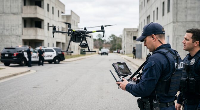
3.0 Tactical Drones for Indoor Room Clearing Operations
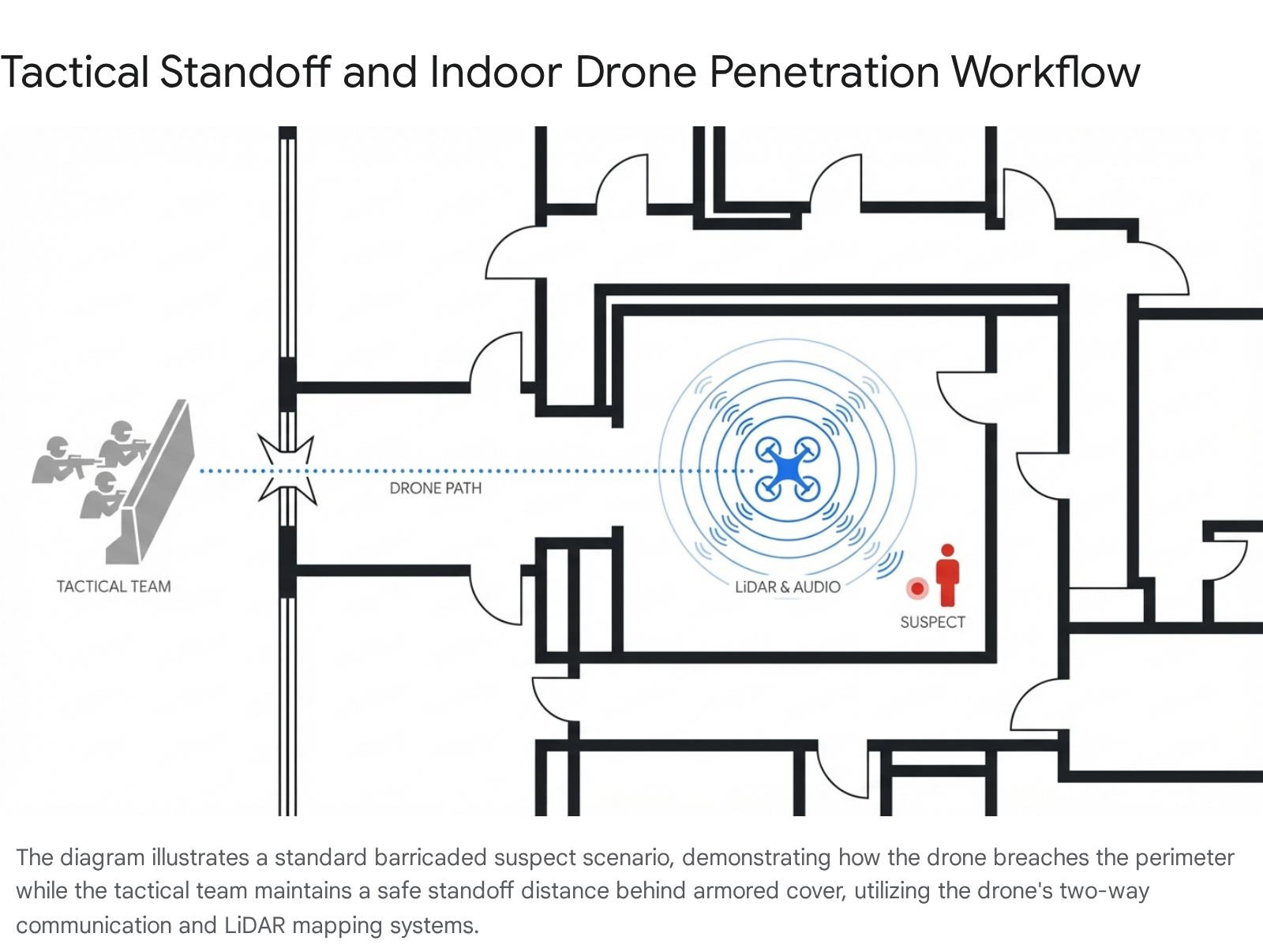
Indoor room clearing is universally recognized within the law enforcement community as one of the most inherently hazardous operations conducted by tactical teams, Special Weapons and Tactics (SWAT) units, and patrol officers. Entering an unknown structure exposes personnel to fatal choke points, concealed suspects, barricades, and unpredictable environmental hazards. The deployment of indoor tactical drones effectively nullifies the traditional “fatal funnel” of a doorway or hallway by providing forward visual intelligence before any human operator crosses the threshold.
3.1 Environmental Challenges and Hardware Requirements
Indoor environments strip drones of their primary navigational aids and safety fallbacks. Without a reliable Global Positioning System (GPS) signal, conventional outdoor drones experience significant drift and loss of control, rendering them useless inside a concrete or steel structure. Furthermore, indoor tactical operations frequently involve navigating through shattered windows, constricted hallways, and heavily cluttered rooms, demanding an exceptionally high degree of collision tolerance. To operate effectively in these hostile environments, modern tactical drones are engineered with highly specific hardware adaptations.
Robust propeller guards are strictly mandatory for indoor platforms. These guards prevent catastrophic crashes when the aircraft inevitably contacts walls, ceilings, or doorframes during tight maneuvers. Additionally, advanced indoor platforms utilize Visual Inertial Odometry (VIO) and downward-facing Light Detection and Ranging (LiDAR) sensors to maintain a stable, autonomous hover without relying on satellite navigation.4 Because indoor drones operate in close proximity to uncooperative suspects and hostile actors, they must also feature self-righting capabilities, commonly referred to as “turtle mode.” This feature ensures that the drone can automatically flip itself over and resume flight operations if it is knocked out of the air by a collision or a physical strike from a suspect.4
3.2 Product Analysis: BRINC Lemur 2
The BRINC Lemur 2 has definitively emerged as a premier, purpose-built tactical drone designed specifically for high-risk law enforcement entry operations. Manufactured in the United States by BRINC Drones, the Lemur 2 incorporates a highly specialized suite of features tailored exclusively for SWAT applications, hostage rescue operations, and barricaded suspect scenarios.2
The physical airframe of the Lemur 2 is constructed with highly durable carbon fiber propeller guards, providing an optimal balance between structural rigidity and overall weight reduction.4 This ruggedized design allows the drone to actively push open ajar doors, an essential maneuver for clearing complex interior layouts without requiring human intervention.2 One of the most distinctive and highly valued tactical features of the Lemur 2 is its integrated glass breaker payload. This rotating device allows the drone to shatter tempered glass windows and breach a structure autonomously, creating its own point of entry without requiring officers to manually break windows and expose themselves to potential gunfire from within the structure.2
Sensor integration on the Lemur 2 is highly advanced and multi-faceted. The drone is equipped with a primary visual camera that features a 180-degree rotation capability, allowing operators to look directly up stairwells or down into basements.2 For operations in zero-light environments, the Lemur 2 utilizes an integrated floodlight, night vision illuminators, and a Teledyne FLIR Boson thermal imaging sensor with a resolution of 640×512 pixels.2 This high-resolution thermal capability is absolutely critical for detecting human heat signatures concealed behind light obstructions or hidden within pitch-dark rooms.
Furthermore, the Lemur 2 acts as a vital tool for crisis negotiation and psychological de-escalation. The aircraft features a sophisticated two-way audio system comprising an integrated loudspeaker and a highly sensitive microphone.2 This acoustic payload enables crisis negotiators to facilitate live, two-way cellular phone calls directly through the hovering drone, maintaining clear communication with barricaded subjects while keeping all law enforcement personnel safely behind armored cover.2 The drone is specifically designed for extended tactical deployments, featuring a “perch” capability that allows it to land inside a structure and transmit live audio and video feeds continuously for up to ten hours on a single battery charge.2
To support complex tactical planning and post-incident analysis, the Lemur 2 utilizes a downward LiDAR sensor and an autonomy engine to generate real-time 3D floor plans of the structure as it flies.2 This spatial mapping data is transmitted back to the command center in real time, providing tactical commanders with accurate architectural layouts to plan secondary entry routes, locate potential escape paths, or coordinate synchronized team movements with extreme precision.4
3.3 Alternative Indoor Platforms
While the BRINC Lemur 2 represents the pinnacle of specialized SWAT drones, other platforms are frequently utilized for interior clearing operations. The Skydio R10 is explicitly marketed as an indoor DFR platform, designed specifically to give officers visual access inside a structure before they physically enter, effectively clearing the way for a safer response to triggered alarms, open doors, or unknown threats.11
Additionally, law enforcement agencies routinely employ lightweight consumer and prosumer models for rapid interior reconnaissance. The DJI Avata 2, categorized as a “cinewhoop” drone, features enclosed propellers and First-Person View goggles, allowing highly skilled pilots to navigate tight interior spaces and stairwells with exceptional cinematic agility.12 Similarly, the Flyability Elios 3 and Elios 2 are entirely enclosed in protective, free-rolling spherical cages, making them highly effective for confined space inspections, industrial environments, and operations where severe collisions with obstacles are guaranteed.12 The HoverAir X1 Pro is also noted as a caged content machine that can be adapted for interior visual capture, while the Autel EVO II Pro 6K provides maximum visual resolution in controlled environments.12
4.0 Unmanned Aerial Systems for Outdoor Perimeter Surveillance
While indoor drones are designed for physical agility and collision tolerance, outdoor perimeter surveillance drones are engineered for flight endurance, optical superiority, and resilience against severe weather conditions. The primary operational goal of an outdoor surveillance UAS is to provide continuous aerial overwatch, conduct rapid visual verification of triggered alarms, and monitor expansive perimeters during major public events or active critical incidents.13
4.1 Evolution of the Perimeter Security Model
The underlying paradigm of perimeter security has fundamentally shifted. Relying solely on human security guards or fixed, stationary cameras is increasingly viewed as insufficient due to limitations in physical mobility, restricted visual range, wage pressures, and labor volatility.13 The modern 2026 perimeter security model integrates human intelligence with robotic automation in a complementary design shift. Drones are now routinely deployed to handle repetitive exterior patrol routes, conduct randomized perimeter checks along fence lines, and provide rapid aerial verification for access control alerts.13 This robotic presence delivers consistent coverage and repeatable video documentation, allowing human personnel to focus exclusively on higher-level judgment, physical response, and command leadership.13
4.2 Product Analysis: Skydio X10 and X10D
The Skydio X10 and its hardened defense-oriented variant, the Skydio X10D, represent the absolute vanguard of autonomous outdoor surveillance platforms. Manufactured by Skydio, the X10 series is a highly capable backpack-portable system weighing under 4.7 pounds that delivers exceptional sensor performance and artificial intelligence capabilities previously unseen in an airframe of this size.15
The operational endurance of the Skydio X10 allows for a maximum flight speed of 45 miles per hour and a maximum flight time of 40 minutes.15 Rapid deployment is a critical feature for first responders, and the X10 can be unpacked, initialized, and launched in less than 40 seconds.15 To ensure continuous operations in highly adverse environments, the aircraft is IP55 certified, providing robust protection against fine dust intrusion and sustained water exposure, such as heavy rain during search and rescue operations.15
The true operational advantage of the Skydio X10 lies in its modular and highly advanced sensor packages. Agencies can equip the drone with either the VT300-Z or VT300-L payload. The VT300-Z payload features a 64-megapixel narrow camera and a 48-megapixel telephoto camera.15 The optical power of this integrated telephoto lens allows law enforcement operators to read a standard vehicle license plate from a massive standoff distance of 800 feet, enabling covert surveillance and suspect tracking without alerting the target to the drone’s presence above.15 Both sensor packages also incorporate a radiometric thermal camera powered by a Teledyne FLIR Boson+ sensor, offering a high thermal resolution of 640×512 pixels with a thermal sensitivity of less than or equal to 30 millikelvins.15 This extreme thermal sensitivity permits operators to detect minute temperature differences, facilitating the rapid location of missing persons in dense foliage or suspects hiding in complete darkness.
Autonomy is the defining characteristic of the entire Skydio platform ecosystem. Powered by an onboard NVIDIA Jetson Orin Graphics Processing Unit, the X10 utilizes six custom navigation lenses to achieve total 360-degree visibility, entirely eliminating sensor blind spots.15 This hardware enables the Skydio Autonomy Engine to perform highly complex obstacle avoidance and spatial mapping.16 Furthermore, the introduction of proprietary “NightSense” technology allows the X10 to fly autonomously and avoid obstacles in zero-light conditions using visible or infrared illumination.15 The Skydio Shadow feature allows the drone to automatically track moving people and vehicles, keeping them perfectly centered in the camera frame even if they briefly pass behind buildings or tree cover.15
Connectivity is maintained through highly advanced datalinks. The Skydio Connect SL provides a local direct transmission link with a range of up to 7.5 miles, while Skydio Connect Fusion seamlessly blends the direct link with 5G or LTE cellular networks, granting operators virtually unlimited range capabilities wherever cellular infrastructure exists.15 The X10D variant is specifically hardened for highly contested military and tactical environments, featuring resilient multi-band radios and Visual Inertial Odometry to navigate and return autonomously even when GNSS and GPS signals are actively jammed or spoofed by hostile electronic warfare equipment.5 The strategic value of this platform is evidenced by the United States Army placing a $52 million order for nearly 3,000 X10D drones, representing the largest single-vendor small UAS purchase in U.S. military history and pushing the implied per-unit cost down significantly through economies of scale.17
4.3 Product Analysis: Parrot ANAFI USA Gov Edition
For law enforcement and federal agencies prioritizing absolute data security, National Defense Authorization Act compliance, and Trade Agreements Act compliance, the Parrot ANAFI USA Gov Edition offers a highly compelling and secure platform.19 Manufactured by Parrot, this drone is designed specifically to meet the stringent security requirements of the U.S. Army and federal agencies, making it an approved platform under the Defense Innovation Unit’s Blue sUAS program.19
The ANAFI USA Gov Edition is exceptionally lightweight, weighing only 500 grams, and features a compact, foldable design that allows for rapid deployment from a patrol vehicle in under 55 seconds.19 Despite its extremely small footprint, it carries a highly capable triple-sensor payload. This includes two 21-megapixel cameras equipped with wide and telephoto lenses, delivering a 32x continuous zoom capability that allows operators to observe subjects clearly from up to two kilometers away.21 Additionally, it integrates a FLIR Boson thermal camera with a resolution of 320×256 pixels, capable of detecting centimetric hot spots from an altitude of 40 meters, making it highly effective for firefighting and search and rescue.21
The flight endurance of the ANAFI USA Gov Edition is rated at 32 minutes per smart battery, and the airframe carries an IP53 certification, ensuring reliable operation in dusty environments and active rainfall.20 However, the paramount feature of the ANAFI USA Gov Edition is its uncompromising approach to cybersecurity, encryption, and data integrity.
Law enforcement drones capture highly sensitive operational intelligence, making data security a critical legal and operational requirement.6 The ANAFI USA ensures that all network links between the drone and the ground controller are authenticated and cyphered with WPA2 protection, utilizing an AES CCMP encryption protocol featuring a 128-bit key.19 Furthermore, the system employs full disk encryption for the onboard SD card, protecting stored videos and photos within a LUKS2 volume encrypted with AES-XTS and a 512-bit key.19 This guarantees that even if the drone is lost during a mission or captured by a hostile party, the sensitive operational data remains entirely inaccessible to forensic analysis without the unique encryption passphrase.19 The drone’s operating system is also highly protected against malicious software modification attempts, as all firmware updates must be digitally signed by Parrot to be accepted by the aircraft’s embedded system.19
4.4 Product Analysis: DJI Matrice 30T and Regulatory Context
The DJI Matrice 30T has historically been a dominant platform for law enforcement agencies requiring heavy-duty outdoor surveillance capabilities. Manufactured by DJI, the Matrice 30T bridges the gap between ultra-portable tactical drones and massive, cumbersome industrial platforms.24
The Matrice 30T boasts a maximum flight time of 41 minutes and is built to withstand extreme weather conditions, carrying an IP55 protection rating and operating effectively in harsh temperatures ranging from -20 degrees Celsius to 50 degrees Celsius.25 The aircraft integrates multiple high-performance sensors, including wide-angle visual cameras, extreme optical zoom capabilities, and a high-resolution thermal imaging sensor, making it a highly effective tool for search and rescue, perimeter monitoring, and post-incident collision reconstruction.25 The drone utilizes the TB30 Intelligent Flight Battery system and the BS30 Intelligent Battery Station, which optimizes charging cycles to maximize battery longevity over hundreds of deployments.28 Furthermore, the Matrice 30T is fully compatible with the DJI Dock system and FlightHub 2 cloud software, allowing for automated, remote deployment operations in a true DFR configuration.24
To facilitate a comprehensive understanding of the operational endurance and rapid response capabilities of these leading platforms, a direct comparison of their maximum flight times and deployment speeds is presented in the table below. The data reveals that while flight times are generally comparable across the heavy-duty models, deployment speeds vary, highlighting the balance manufacturers strike between portability and sensor capacity.
| Drone Model | Maximum Flight Time | Deployment Time |
| DJI Matrice 30T | 41 Minutes 25 | ~60 Seconds (Estimated class average) |
| Skydio X10 | 40 Minutes 15 | < 40 Seconds 15 |
| Parrot ANAFI USA Gov | 32 Minutes 20 | < 55 Seconds 19 |
However, the procurement and operational landscape for DJI products in the United States has been significantly altered by stringent federal regulatory actions. In recent years, severe concerns regarding national security and data privacy led the Federal Communications Commission to place DJI on a “Covered List,” effectively blocking telecommunications authorization for new foreign-made models.29 It is absolutely crucial to understand the exact parameters of this restriction as it applies to law enforcement operations in 2026.
The current regulatory framework does not constitute a blanket ban or a retroactive grounding order on flying existing DJI drones.30 Existing DJI platforms that previously received FCC approval, such as the Matrice 30T, Matrice 350 RTK, and Mavic 3 series, remain entirely legal to operate, import, and sell within the United States, provided they were approved prior to the restriction.30 There has been no remote disablement of active fleets, and law enforcement agencies can legally continue to deploy their current DJI aircraft for active DFR operations without violating federal flight rules.30
The primary operational impact of the FCC updates relates to long-term supply chain continuity, equipment lifecycles, and the procurement of future hardware.31 Any future, newly developed drone models from DJI cannot receive FCC authorization and are therefore completely blocked from entering the U.S. market.30 Furthermore, while existing models remain approved, replacing critical components such as transmission hardware or proprietary controllers involves tighter regulatory oversight and strict documentation defensibility, potentially causing critical delays in equipment replacement.31 This sustained regulatory pressure has accelerated a massive market shift, prompting many agencies to transition their fleets toward American-made, NDAA-compliant alternatives like Skydio and BRINC to ensure long-term program continuity and entirely mitigate geopolitical supply chain risks.7
5.0 Integration with Real-Time Crime Center Software Platforms
The acquisition of advanced aerial hardware represents only a fraction of a successful and mature modern drone program. The true transformative tactical value of these assets is realized when the raw data they collect is instantly ingested, analyzed, and distributed through a centralized software ecosystem known as a Real-Time Crime Center. Historically, an RTCC required a massive physical command center outfitted with walls of expensive monitors and dedicated, stationary operators.32 Today, profound advancements in cloud computing have decentralized the RTCC concept, allowing the same unified operational picture to be accessed securely on mobile devices by incident commanders in the field or by officers in their patrol vehicles.32
The primary function of RTCC software is to break down rigid data silos. Municipalities generate vast amounts of data from disparate sources, including community-owned cameras, traffic monitoring cameras, body-worn cameras, Automated License Plate Recognition systems, Computer-Aided Dispatch systems, and active drone telemetry.32 Without an integration platform, dispatchers must simultaneously monitor multiple independent screens to synthesize a response. Modern RTCC software consolidates these dynamic feeds into a single-pane-of-glass interface. The foundational network architecture of a modern RTCC relies on a centralized cloud engine that actively ingests raw telemetry and video feeds from edge devices, such as aerial drones, public cameras, and ALPR sensors. This central correlation engine processes the disparate data streams, applying mapping algorithms and artificial intelligence analysis, before routing a unified, actionable operational picture outward to command center displays and mobile patrol tablets utilized by field personnel. This structured data flow ensures that ground units and command staff operate with synchronized intelligence during critical incidents.
5.1 Axon Fusus Integration
Axon Fusus serves as a premier cloud-based RTCC platform designed specifically to collapse the critical time gap between the initial signal of an incident and the corresponding police response.33 The platform achieves this operational velocity by providing officers, command staff, and remote dispatchers with the exact same live operational picture simultaneously.33
Fusus resolves historic, highly complex hardware integration challenges through the deployment of a physical networking appliance known as the FususCORE.34 This small digital device plugs directly into existing camera hardware or local network switches, establishing an automated, highly secure tunnel to the Fusus cloud platform.34 This architectural innovation eliminates the need for agencies to purchase expensive new DVR systems or proprietary cameras, drastically reducing setup time and infrastructure costs while vastly increasing the number of accessible video feeds from cooperating residents and local businesses.34
Integrating dynamic, fast-moving video sources like drones and police helicopters has traditionally been difficult for fixed-camera video management systems. However, Fusus seamlessly ingests live drone telemetry and high-definition video feeds through its Axon Air integration framework.33 When a drone is launched, its live video feed, precise geographic location, and camera orientation appear directly on the unified Fusus map, perfectly synchronized alongside the GPS locations of responding officers, active 911 call data, and ALPR overlays.33 This synchronized alignment ensures that the ground team is never entering a scene blind; commanders can identify hazards, track fleeing suspects, and communicate safe approach vectors in real time.1
Furthermore, Fusus streamlines incident management workflows directly from the CAD feed. Operators can launch an incident from a dispatch ticket, and the system will automatically activate and display all relevant cameras and data assets in the immediate geographic vicinity, including public tips and dynamic video feeds.34 Looking toward the future of DFR, Axon is finalizing a one-click drone request feature within Fusus that will allow operators to dispatch a DFR drone directly to an officer’s real-time GPS location with absolute pinpoint accuracy, providing immediate aerial overwatch at the push of a button.35 All digital evidence captured by the drones and integrated systems can be uploaded directly to Axon Evidence, seamlessly preserving an unbroken chain of custody for subsequent judicial prosecution.33 It is also worth noting industry dynamics within the RTCC space; Axon recently chose to sever certain expansive open API relationships with competitors like Flock Safety, pushing agencies toward deeper integration within the proprietary Axon ecosystem.36
5.2 Genetec Citigraf Integration
Genetec Citigraf provides law enforcement agencies with comprehensive, data-driven situational awareness designed specifically for strategic decision support and rapid response coordination.37 Rather than functioning merely as a passive video viewer, Citigraf acts as a powerful, proactive correlation engine.37 When a CAD call is received, the Citigraf correlation engine automatically aggregates and populates the map with all potentially related historical and real-time data connected to that specific time and location, highlighting subtle connections and crime trends that human operators might easily overlook during a high-stress event.37
To facilitate advanced aerial operations, Genetec developed the highly specialized Drone Dispatcher plugin, which provides deep, seamless integration of professional drone fleets directly into the Genetec Security Center interface.38 This plugin enables real-time mission control, video streaming, and telemetry access, granting operators full situational awareness from the air without ever needing to switch software platforms or utilize secondary monitors.38 The integration supports real-time GPS tracking of the aircraft, interactive mission dispatching initiated directly from the graphical map, and centralized fleet management and mission playback capabilities.38 Crucially, the Drone Dispatcher plugin supports both manual piloting controls and fully automated drone dispatch to incident locations, serving as a robust software foundation for automated DFR programs.38
The operational impact of Citigraf is substantial across major municipalities. Agencies utilizing the platform report significant efficiency gains. For example, the Mesa Police Department utilizes Citigraf to successfully monitor over 800 city cameras, ALPR data, mobile Police Observation Devices, and real-time drone video within a unified RTCC, extending critical, real-time intelligence directly to patrol officers on the street and dramatically improving overall emergency response coordination.39
5.3 Motorola CommandCentral Aware Integration
Motorola Solutions CommandCentral Aware is an advanced command center software platform that unifies real-time data, voice communications, and video feeds to significantly enhance incident resolution.40 CommandCentral Aware provides a premier centralized hub where command staff can direct complex drone missions, analyze aerial intelligence, and seamlessly share data across the entire incident response workflow on a single pane of glass.40
A critical operational differentiator for Motorola is the deep, native integration between aerial hardware, cloud software, and the physical communications equipment carried by officers on daily patrol. Through strategic corporate alliances with drone manufacturers like BRINC, Motorola has enabled a seamless DFR dispatch capability tied directly to the officer’s radio hardware.40 If an officer is in distress and activates the physical emergency button on their APX NEXT smart radio, the action instantly triggers a priority mission in CommandCentral Aware.40 A BRINC Responder drone can automatically launch and fly directly to the officer’s geographic location, or their projected location during a high-speed foot pursuit, providing immediate aerial support and streaming vital video back to command.40 Motorola has also recently partnered with BRINC to support the release of the Guardian drone, which represents the world’s first Starlink-connected drone, ensuring uninterrupted connectivity even in areas with poor cellular infrastructure.42
Furthermore, CommandCentral Aware incorporates an advanced artificial intelligence assistant known as Assist AI. This system actively analyzes adjacent information sources, including live transcriptions of active radio traffic and VESTA 9-1-1 calls.40 If the AI detects critical keywords, such as “heart attack,” “allergic reaction,” or “officer down,” it automatically flags the information for the dispatcher and recommends the immediate deployment of a payload-equipped drone.40 The drone can carry life-saving medical equipment, like a defibrillator, EpiPen, or flotation device, directly to the scene faster than ground units can navigate traffic.40
Motorola also directly addresses the rapidly growing threat of hostile or unauthorized drones interfering with public safety operations. Through a deep software integration with SkySafe, CommandCentral Aware provides industry-leading airspace security and counter-UAS technology directly within the mapping interface.44 This integration allows operators to visualize active drone flights, establish alert zones, and receive real-time notifications if an unauthorized drone breaches a protected perimeter.45 SkySafe’s unique “forensics as a service” capability allows law enforcement to extract flight logs and media from malicious drones, compiling prosecution-ready documentation to ensure legal accountability in court without requiring personnel to learn a separate software workflow or monitor separate systems.44
6.0 Strategic Procurement, Vendor Sourcing, and Pricing Analysis
The acquisition of highly specialized law enforcement drones requires meticulous evaluation of authorized vendors to ensure supply chain integrity, continuous warranty support, and highly competitive pricing. Cooperative Purchasing Vehicles, such as Sourcewell and BuyBoard, are actively revolutionizing the way public safety agencies acquire this technology by eliminating the need for individual, protracted bidding processes.46 These service cooperatives ensure that all purchases meet strict state and local compliance requirements while offering pre-negotiated, competitive pricing derived from collective bargaining power.46 For example, agencies can procure BRINC offerings under the Unmanned Aerial Vehicles category #718-23 through BuyBoard, or utilize Sourcewell contract #011223 for systems like the Skydio X10.46
Furthermore, agencies operating in states with restrictive procurement laws, such as Florida, must adhere to strict legislative guidelines. The Florida Department of Management Services established Rule 60GG-2.0075, which mandates minimum security requirements and restricts the purchase of non-approved drones by governmental entities, heavily favoring domestic manufacturers on the approved list.47
The following sections detail the manufacturer URLs, prevailing market prices, and five currently available authorized vendors for the primary tactical drones discussed in this report. The prices listed reflect the observed minimum to average retail costs for baseline packages or demo units, exclusive of recurring software licensing, specialized proprietary payloads, or multi-year safeguard warranties.
6.1 Procurement Data: DJI Matrice 30T
Despite regulatory shifts impacting future models, the Matrice 30T remains a highly available and legal platform for agencies purchasing through commercial drone distributors. The observed pricing structure reflects heavy competition among major enterprise drone retailers.
- Manufacturer URL: https://enterprise.dji.com/matrice-30 24
- Observed Price Range: The minimum observed price for the base Matrice 30T package is $11,656.00, while the average market price across leading vendors sits at approximately $12,385.00.28 The vendors listed below fall precisely within this minimum-to-average price spectrum and currently list the product in stock.
| Vendor Name | Product Listing URL | Listed Price | Stock Status |
| Drone Nerds | https://www.dronenerds.com/collections/drones-enterprise-drones-dji-m30-series/products/dji-matrice-30t-m30t-drone | $11,656.00 | In Stock 49 |
| Dronefly | https://www.dronefly.com/collections/dji-matrice-series | $11,656.00 | In Stock 48 |
| Covert Drones | https://covertdrones.com/collections/dji-matrice-30t-thermal-drone-and-bundles | $12,399.00 | In Stock 50 |
| Quadrocopter | https://shop.quadrocopter.com/DJI-Matrice-30T_p_2027.html | $12,602.00 | In Stock 51 |
| Global Drone HQ | https://globaldronehq.com/products/dji-matrice-30t-enterprise-drone | $12,602.00 | In Stock 28 |
(Note: Quadrocopter and Global Drone HQ are included slightly above the strict average to satisfy the five-vendor requirement based on available stock data, reflecting standard market variance for enterprise bundles).
6.2 Procurement Data: Parrot ANAFI USA Gov Edition
The ANAFI USA Gov Edition is positioned as a highly secure, NDAA-compliant alternative, widely available through established enterprise drone retailers. Pricing for this specific government-tier model is strictly controlled and remarkably uniform across the retail ecosystem.
- Manufacturer URL: https://www.parrot.com/en/drones/anafi-usa 21
- Observed Price Range: The price for the ANAFI USA Gov Edition is uniformly observed at $14,000.00 across the market, establishing both the minimum and the average price simultaneously.52 The vendors listed below currently have the product in stock at this precise price point.
| Vendor Name | Product Listing URL | Listed Price | Stock Status |
| Florida Drone Supply | https://www.floridadronesupply.com/products/parrot-anafi-usa-gov-edition | $14,000.00 | In Stock 52 |
| Drone Nerds | https://www.dronenerds.com/products/parrot-anafi-usa-gov-pf728230 | $14,000.00 | In Stock 53 |
| Blue Skies Drone Shop | https://www.blueskiesdroneshop.com/products/parrot-anafi-usa-gov-edition | $14,000.00 | In Stock 54 |
| Drone Works | https://drone-works.com/drones/enterprise-drones/parrot-anafi-usa/ | $14,000.00 | In Stock 55 |
| Crutchfield | https://www.crutchfield.com/p_333PF72823/Parrot-ANAFI-USA-GOV-Edition.html | $14,000.00 | In Stock 56 |
6.3 Procurement Data: BRINC Lemur 2 and Skydio X10
Due to the highly specialized, military-grade nature of both the BRINC Lemur 2 and the Skydio X10, these platforms are not typically sold through conventional open-market retail channels with simple shopping cart functionalities. Instead, they are distributed exclusively through a tightly controlled network of authorized enterprise resellers, defense contractors, and direct municipal bid systems.16
For the BRINC Lemur 2 (https://brincdrones.com/lemur-2/), observed pricing ranges from $6,000.00 for demo units to $16,999.00 for complete operational kits procured through municipal bids.8 The VSA contract pricing lists the airframe alone at $11,749.00.58 Authorized vendors equipped to facilitate these sales include Genpac Drones, DSLRPros, Drone Nerds, and Florida Drone Supply.9
For the Skydio X10 (https://www.skydio.com/x10), prices vary dramatically based on the selected sensor payload and connectivity modules, ranging from $16,000.00 up to $28,382.00 for fully equipped configurations.15 Procurement is facilitated globally by a vast network of authorized resellers. In the United States, prominent authorized vendors include Adorama Drones, Safeware, SISO Air, Frontier Precision, and Carahsoft, all of which hold specific government supply contracts to fulfill law enforcement acquisitions.16
7.0 Conclusion
The strategic integration of Unmanned Aerial Systems into law enforcement operations represents a permanent and highly transformative evolution in public safety methodology. As demonstrated throughout this extensive analysis, the deployment of purpose-built hardware yields immediate and profound tactical advantages. Indoor drones like the BRINC Lemur 2 systematically mitigate the lethal risks associated with close-quarters room clearing, providing crisis negotiators and SWAT commanders with crucial visual intelligence, real-time 3D mapping, and effective de-escalation tools without ever exposing human personnel to hostile fire. Concurrently, outdoor perimeter surveillance platforms, notably the Skydio X10 and the Parrot ANAFI USA Gov Edition, deliver unparalleled aerial overwatch capabilities, utilizing advanced radiometric thermal imaging and autonomous navigation systems to maintain impenetrable security across expansive environments regardless of lighting or extreme weather conditions.
However, the ultimate efficacy of these aerial assets is entirely defined by their integration into the broader law enforcement digital ecosystem. The true capability multiplier resides within cloud-based Real-Time Crime Center software platforms such as Axon Fusus, Genetec Citigraf, and Motorola CommandCentral Aware. By aggressively dissolving historical data silos and fusing live drone telemetry with CAD data, body-worn camera feeds, ALPR tracking, and automated dispatch triggers, these platforms ensure that collected intelligence is instantly actionable. The synthesis of robust aerial hardware, stringent military-grade data security protocols, and unified cloud-based software architectures ensures that modern law enforcement agencies can respond to critical incidents with unprecedented speed, objective transparency, and maximal operational safety.
Works cited
- Police Drones in 2026: The complete guide to law enforcement UAS – Motorola Solutions, accessed April 15, 2026, https://www.motorolasolutions.com/en_us/blog/police-drones
- Police & Law Enforcement Drones, accessed April 15, 2026, https://brincdrones.com/police-drones/
- BRINC – Technology in the Service of Public Safety, accessed April 15, 2026, https://brincdrones.com/
- LEMUR 2 – New, Improved and Shipping Now – BRINC, accessed April 15, 2026, https://brincdrones.com/news/lemur-2-new-improved-and-shipping-now/
- Skydio X10D, accessed April 15, 2026, https://www.skydio.com/x10d
- The Best Drones for Law Enforcement: What Agencies Need to Know – Flock Safety, accessed April 15, 2026, https://www.flocksafety.com/blog/best-drones-for-law-enforcement
- Top American-Made Drones for 2025 (NDAA and Blue UAS Compliant Models) – DSLRpros, accessed April 15, 2026, https://www.dslrpros.com/blogs/rescue-drones/top-american-made-drones-for-2025-ndaa-and-blue-uas-compliant-models
- LEMUR 2 Drone – BRINC, accessed April 15, 2026, https://brincdrones.com/lemur-2/
- BRINC LEMUR-S Tactical Drone Kit (Demo Unit) – GenPac Drones, accessed April 15, 2026, https://www.genpacdrones.com/product/brinc-lemur-tactical-drone-kit-2/
- LEMUR 2 FAQs – BRINC, accessed April 15, 2026, https://brincdrones.com/lemur-2-faqs/
- Indoor Drone as First Responder with Skydio R10, accessed April 15, 2026, https://www.skydio.com/solutions/dfr/indoor-dfr
- Inside the room: the most powerful indoor drones of 2026 – Gadget Flow, accessed April 15, 2026, https://thegadgetflow.com/blog/inside-the-room-the-most-powerful-indoor-drones-of-2026/
- Exterior Guard Patrols Were a 2025 Solution. The 2026 Perimeter Security Model Is Different – Asylon Robotics, accessed April 15, 2026, https://asylonrobotics.com/resources/blog/2026-perimeter-security-model/
- Security Drones: An In-Depth Guide [New for 2026] – UAV Coach, accessed April 15, 2026, https://uavcoach.com/security-drones/
- Skydio X10, accessed April 15, 2026, https://www.skydio.com/x10
- Skydio Authorized Resellers | Skydio, accessed April 15, 2026, https://www.skydio.com/authorized-resellers
- Skydio Wins $52 Million Army Order For Nearly 3,000 X10D Drones, The Largest Single-Vendor SUAS Purchase In U.S. Military History, accessed April 15, 2026, https://dronexl.co/2026/03/22/skydio-x10d-army-52-million-order/
- U.S. Army Places $52+ Million Order for Skydio X10D, the Largest Single-Vendor Tactical sUAS Order in Army History, accessed April 15, 2026, https://www.skydio.com/blog/u-s-army-usd52-million-order-skydio-x10d
- Parrot Anafi USA (Gov) – GenPac Drones, accessed April 15, 2026, https://www.genpacdrones.com/product/parrot-anafi-usa-gov/
- Parrot ANAFI USA Gov Edition – Advexure, accessed April 15, 2026, https://advexure.com/products/parrot-anafi-usa-gov-edition
- Parrot ANAFI USA – Professional Drone made in USA., accessed April 15, 2026, https://www.parrot.com/en/drones/anafi-usa
- 7 Best Public Safety Drone 2026 (A Complete Buying Guide) – JOUAV, accessed April 15, 2026, https://www.jouav.com/blog/public-safety-drone.html
- Parrot Professional Drones ANAFI USA Packs | Buy Online, accessed April 15, 2026, https://www.parrot.com/en/drones/anafi-usa/buy
- Matrice 30 Series – Industrial grade mapping inspection drones – DJI Enterprise, accessed April 15, 2026, https://enterprise.dji.com/matrice-30
- Unmanned Aircraft System (UAS) Proposed Law Enforcement Equipment Use Policy | San Francisco Police Department, accessed April 15, 2026, https://www.sanfranciscopolice.org/unmanned-aircraft-system-uas-proposed-law-enforcement
- Matrice 350 RTK – DJI Enterprise, accessed April 15, 2026, https://enterprise.dji.com/matrice-350-rtk
- Law Enforcement – DJI Enterprise, accessed April 15, 2026, https://enterprise.dji.com/public-safety/law-enforcement
- DJI Matrice 30T Drone – Global Drone HQ, accessed April 15, 2026, https://globaldronehq.com/products/dji-matrice-30t-enterprise-drone
- Skydio poised for $4M windfall from LAPD drone deal – DroneDJ, accessed April 15, 2026, https://dronedj.com/2026/02/18/skydio-drone-dock-lapd-police/
- The DJI Ban Explained [New for 2026] | Guide – MFE Inspection Solutions, accessed April 15, 2026, https://mfe-is.com/dji-ban/
- What the FCC Update Means for Police DFR Programs Using DJI in 2026 – DSLRPros, accessed April 15, 2026, https://www.dslrpros.com/blogs/drone-trends/what-the-fcc-update-means-for-police-dfr-programs-using-dji-in-2026
- The Ultimate Guide to Real-Time Crime Centers – Axon.com, accessed April 15, 2026, https://www.axon.com/resources/real-time-crime-center
- Axon Fusus | Real‑Time Intelligence Platform for Public Safety, accessed April 15, 2026, https://www.axon.com/products/axon-fusus
- Real-time crime center in the cloud: the next generation of police technology – Axon.com, accessed April 15, 2026, https://www.axon.com/resources/real-time-crime-center-in-the-cloud-the-next-generation-of-police-technology
- Five Major Developments in U.S. Law Enforcement to Watch – Axon – GACP – Georgia Association of Chiefs of Police, accessed April 15, 2026, https://gachiefs.com/ga-chief-magazine/axon-advertorial-2-2-3/
- Axon Plans to Sever APIs With Flock – Flock Safety, accessed April 15, 2026, https://www.flocksafety.com/blog/axon-plans-to-sever-apis-with-flock
- Citigraf key features and portfolio – Genetec Inc, accessed April 15, 2026, https://www.genetec.com/products/operations/citigraf/portfolio
- Drone Dispatch Framework – Genetec Inc, accessed April 15, 2026, https://www.genetec.com/partners/partner-integration-hub/addonxpert/drone-dispatch-framework
- Boosting RTCC operations at Mesa Police Department – Genetec Inc, accessed April 15, 2026, https://www.genetec.com/customer-stories/mesa-police-department
- Motorola Solutions Brings Drone Dispatch to APX NEXT Radios, Advancing Officer Safety, accessed April 15, 2026, https://www.motorolasolutions.com/newsroom/press-releases/motorola-solutions-brings-drone-dispatch-to-apx-next-radios.html
- CommandCentral Aware – Motorola Solutions EMEA, accessed April 15, 2026, https://www.motorolasolutions.com/en_xu/products/command-center-software/real-time-intelligence-operations/command-central-aware.html
- BRINC Unveils Guardian, Launching the Next Era of Drone as First Responder – Motorola Solutions, accessed April 15, 2026, https://www.motorolasolutions.com/newsroom/press-releases/brinc-unveils-guardian-drone-as-first-responder.html
- BRINC & Motorola Solutions | First Responder Drones – Callmc, accessed April 15, 2026, https://callmc.com/brinc-motorola-solutions-drone-public-safety/
- Motorola Solutions and SkySafe unveil drone airspace security integration, accessed April 15, 2026, https://www.motorolasolutions.com/en_us/blog/drone-airspace-security-integration
- CommandCentral Aware + SkySafe Integration Fact Sheet – Motorola Solutions, accessed April 15, 2026, https://www.motorolasolutions.com/content/dam/msi/docs/product-marketing/commandcentral-aware/commandcentral-aware-safesky-integration-fact-sheet.pdf
- BRINC and Cooperative Purchasing Vehicles, accessed April 15, 2026, https://brincdrones.com/news/cooperative-purchasing/
- File #: 24-0966 – City of Pembroke Pines, FL – Calendar, accessed April 15, 2026, https://ppines.legistar.com/LegislationDetail.aspx?ID=6995390&GUID=8E650535-4561-4650-8337-23DEFA64C7FD&FullText=1
- Shop DJI Matrice Series Drones, Parts & Accessories | Dronefly, accessed April 15, 2026, https://www.dronefly.com/collections/dji-matrice-series
- DJI Matrice 30T M30T Enterprise Thermal Drone (No Batteries), accessed April 15, 2026, https://www.dronenerds.com/collections/drones-enterprise-drones-dji-m30-series/products/dji-matrice-30t-m30t-drone
- DJI Matrice 30T Thermal Drone and Bundles – Covert Drones, accessed April 15, 2026, https://covertdrones.com/collections/dji-matrice-30t-thermal-drone-and-bundles
- DJI Matrice 30T Thermal Industrial Drone, accessed April 15, 2026, https://shop.quadrocopter.com/DJI-Matrice-30T_p_2027.html
- Parrot – Florida Drone Supply, accessed April 15, 2026, https://www.floridadronesupply.com/collections/parrot
- Shop Parrot ANAFI USA | GOV Edition – Drone Nerds, accessed April 15, 2026, https://www.dronenerds.com/products/parrot-anafi-usa-gov-pf728230
- Parrot – Anafi USA GOV Edition – Blue Skies Drones, accessed April 15, 2026, https://www.blueskiesdroneshop.com/products/parrot-anafi-usa-gov-edition
- Parrot ANAFI USA – Drone-Works, accessed April 15, 2026, https://drone-works.com/drones/enterprise-drones/parrot-anafi-usa/
- Parrot ANAFI USA GOV Edition Aerial drone bundle with thermal/electro-optical sensors and smart remote controller at Crutchfield, accessed April 15, 2026, https://www.crutchfield.com/p_333PF72823/Parrot-ANAFI-USA-GOV-Edition.html
- Bid Details – Upcoming RFB’s Search, accessed April 15, 2026, https://pol.co.monmouth.nj.us/BidDetails?ID=F-61-2024&BidType=1
- Lemur Safeguard – Minimum 3 years – Require signed BRINC MSPA – VendorLink, accessed April 15, 2026, https://www.myvendorlink.com/external/vfile?d=vrf&s=161269&v=85604&sv=0&i=105&ft=b
- Skydio X10 Battin: v40.273 – 5 February 2026, accessed April 15, 2026, https://support.skydio.com/hc/en-us/articles/46227076099355-Skydio-X10-Battin-v40-273-5-February-2026
- Florida Drone Supply – Authorized DJI, Autel, Teledyne & Parrot Dealer, accessed April 15, 2026, https://www.floridadronesupply.com/
- Blue Unmanned Aircraft Systems for First Responders in an Urban Environment – Homeland Security, accessed April 15, 2026, https://www.dhs.gov/sites/default/files/2026-01/25_0604_st_blueuasar_0%20%284%29.pdf