1. Executive Summary
The Mount Samat National Shrine, formally designated as Dambana ng Kagitingan (Shrine of Valor), stands as one of the most structurally and historically significant military memorial complexes in the Republic of the Philippines.1 Situated near the summit of Mount Samat in the municipality of Pilar, Bataan, the shrine was established to immortalize the tactical resistance and ultimate sacrifice of Filipino and American forces against the Imperial Japanese Army during the 1942 Battle of Bataan.1 Commissioned in 1966 by President Ferdinand E. Marcos, the 75-hectare core heritage site forms the geographic and symbolic anchor of World War II memory in the Pacific Theater, capturing the profound geopolitical shifts of the mid-twentieth century.1
Structurally, the complex is defined by two primary architectural elements: a sprawling marble Colonnade that serves as a ceremonial altar, and a towering 95-meter Memorial Cross that dominates the peninsula’s skyline.4 Designed by Architect Lorenzo del Castillo with extensive sculptural integration by National Artist Napoleon Abueva, the shrine represents a masterful fusion of monumental mid-century architecture, modernist sculpture, and military historiography.6 Its engineering, situated on the rim of an extinct volcanic crater 555 meters above sea level, required significant logistical and structural innovation, culminating in its formal inauguration in 1970.1
Beyond its physical architecture, the shrine operates as a living administrative and economic entity. Under the joint stewardship of the Philippine Veterans Affairs Office (PVAO) and the Tourism Infrastructure and Enterprise Zone Authority (TIEZA), the site is currently undergoing a comprehensive, multi-phase redevelopment.8 Designated as a Flagship Tourism Enterprise Zone (FTEZ), the complex is expanding to integrate heritage preservation with sustainable economic development.3 This includes the development of a 144-hectare locator site and the construction of a newly capitalized Visitors Complex.3 This report provides a detailed analysis of the historical commissioning, architectural framework, engineering parameters, artistic iconography, and modern operational evolution of the Mount Samat National Shrine.
2. Historical Antecedents: The Strategic Defense of Bataan (1941-1942)
The conceptualization and geographic placement of the Mount Samat National Shrine are deeply rooted in the tactical realities of the 1942 Bataan campaign. Following the surprise attack on Pearl Harbor and the subsequent Japanese invasion of Luzon in December 1941, the United States Army Forces in the Far East (USAFFE)—commanded initially by General Douglas MacArthur and later by Lieutenant General Jonathan Wainwright—executed a strategic withdrawal to the Bataan Peninsula.4 This maneuver was dictated by War Plan Orange-3, a long-standing American military doctrine designed to concentrate defending forces in central Luzon and deny the Imperial Japanese Navy access to the strategic anchorage of Manila Bay.10
Mount Samat, rising 555 meters (1,821 feet) above sea level, served as the focal point of the critical Orion-Bagac defensive line.2 Its elevated topography and dense jungle canopy provided the Philippine Commonwealth Army and American artillery units with an advantageous vantage point to suppress the advancing 14th Japanese Imperial Army, commanded by Lieutenant General Masaharu Homma.11 The mountain dominated the valley below, allowing USAFFE artillery to throw a highly effective curtain of barrage fire against Japanese forces attempting to break through the defensive perimeter.11
However, the strategic situation rapidly deteriorated due to disrupted supply lines, rampant disease, and overwhelming enemy air superiority. During the second major Japanese offensive, Mount Samat was systematically neutralized by intense carpet bombing and concentrated artillery barrages.11 The bombardment severed communication lines, shrouded the mountain in smoke, and incinerated the foliage with incendiary bombs, ultimately fracturing the Allied defense.11 After four months of grueling combat, approximately 78,000 exhausted, sick, and starving Filipino and American soldiers, under the local command of Major General Edward P. King, surrendered to the Japanese on April 9, 1942.1
This capitulation marked the single largest surrender of United States military personnel in history.1 The prisoners of war were subsequently forced into the Bataan Death March, a brutal 182-kilometer forced transit from Mariveles and Bagac to Camp O’Donnell in Capas, Tarlac, during which thousands perished from abuse, starvation, and disease.4 The sheer scale of this sacrifice established the Bataan Peninsula—and Mount Samat specifically—as hallowed ground, necessitating a monument of unprecedented scale to adequately contextualize the tactical defeat as a triumph of endurance and martial spirit.12
3. Commissioning and Administrative Origins (1966-1970)
The physical memorialization of the Bataan campaign required a distinct shift in national historiography, transforming a military capitulation into an enduring narrative of collective valor and delayed enemy timetables. Shortly after assuming the presidency in 1965, Ferdinand E. Marcos—himself a veteran who claimed guerrilla service during the conflict—conceived the Dambana ng Kagitingan as a fitting monument to this strategic sacrifice.3 The objective was to create a permanent installation that would honor the allied forces and serve as a physical testament to the Philippine commitment to democratic defense.3
The legal and administrative groundwork was established rapidly in the spring of 1966. On April 14, 1966, coinciding with the annual Bataan Day commemoration, President Marcos officially laid the cornerstone for the project on the summit of Mount Samat.1 Four days later, on April 18, Marcos issued Proclamation No. 25, which legally excised the specific Mount Samat area from the broader Bataan National Park Reservation (which had been established previously in December 1945) and designated the 73,665-hectare area exclusively as the Mount Samat National Shrine.5
Funding a civil engineering project of this magnitude atop a mountain presented immediate fiscal challenges for the national government. On September 10, 1966, through Proclamation No. 103, the government authorized a nationwide fund campaign under the National Shrines Commission to finance the development without relying entirely on direct state appropriations.14 A dedicated campaign committee was established, headed by Colonel Ernesto D. Rufino, the prominent president of the Merchants Bank, to source private and public contributions.5
Despite these high-profile efforts, initial fundraising fell significantly short of the required capital. Due to this severe lack of funds, construction schedules were delayed, preventing the shrine from being completed in time for the 25th anniversary of the Fall of Bataan in 1967 as originally intended.1 The fund campaign period was subsequently extended multiple times—eventually running until December 1972—to sustain the necessary cash flow for the massive civil works.5 Through a combination of persistent fundraising and eventual government subsidization, the shrine was completed and formally inaugurated in 1970, strategically timed to align with the 25th anniversary of the end of World War II.1
4. Architectural Master Plan and Landscape Integration
The architectural master plan for the Mount Samat National Shrine was entrusted to Lorenzo del Castillo, who was tasked with designing a monument that balanced immense physical scale with the solemn requirements of a national memorial.6 The initial concept proposed by the National Shrines Commission called for a 60-meter cross equipped with a sightseeing elevator, accompanied by a separate Memorial Chapel and a Hall of Fame featuring wide concourses.6
As the design evolved, practical, aesthetic, and financial considerations led to a significant modification of this layout. The standalone Memorial Chapel and Hall of Fame concepts were merged and reinterpreted into the expansive Colonnade structure that exists today.5 Simultaneously, the scale of the Memorial Cross was drastically increased from the originally planned 60 meters to a towering 95 meters, ensuring its visibility across the entirety of the Bataan Peninsula and Manila Bay.4
The integration of the massive structures with the rugged mountain terrain was overseen by landscape architect Dolly Quimbo Perez.6 Her design philosophy emphasized the solemn approach to the monument. From the Colonnade, visitors must ascend a 14-flight zigzagging footpath built directly into the mountain slope.6 Crucially, this path is paved with “bloodstones”—red-hued rocks sourced directly from Corregidor Island.16 This landscape choice is deeply symbolic, physically and thematically linking Mount Samat and Corregidor, the two ultimate bastions of Allied resistance in the Philippines, beneath the feet of the visitor.17
A central tenet of Castillo’s design was the seamless incorporation of fine arts to articulate the historical narrative. To achieve this, the government commissioned Professor Napoleon V. Abueva—who would later be recognized as the Father of Modern Philippine Sculpture and conferred the title of National Artist—to execute the massive bas-reliefs and high-reliefs that clad both the Colonnade and the Memorial Cross.18 The stained glass elements of the complex were designed by Professor Cenon Rivera and fabricated by Vetrate D’Arte Giuliani in Rome, Italy, adding a layer of European artisanal craftsmanship to the Filipino architectural framework.6
5. Structural Engineering and Construction Dynamics
The execution of Castillo and Abueva’s designs required overcoming severe logistical and geographic hurdles. Mount Samat is geologically classified as a parasitic cone of the larger Mount Mariveles caldera, and the shrine sits near the edge of a 550-meter-wide crater that opens to the northeast.2 Constructing a massive, wind-resistant vertical structure at 555 meters above sea level necessitated specialized engineering to withstand typhoon-force winds and the seismic activity endemic to the Western Bataan Lineament.2
Initial site preparation and access road construction were handled by the 51st Engineer Brigade of the Armed Forces of the Philippines (AFP), which cut through the dense jungle to allow heavy construction machinery to reach the summit.6 The asphalting and ongoing maintenance of these vital access roads were managed by the Bataan Bureau of Public Highways under the direction of Engineer Jose C. Aliling.6 Structural engineering consultation for the monuments was provided by DCCD Engineering Corporation, led by Dr. Salvador F. Reyes, ensuring the cross’s foundation was deeply anchored into the volcanic rock.6
The primary construction contract was awarded to D.M. Consunji, Inc. (DMCI) on January 16, 1967.5 The structural steel framework, which was essential for the cross’s rigidity and for housing the internal elevator apparatus, was fabricated and erected by the Atlantic Gulf & Pacific Co. (AG&P).6
The construction process was heavily impacted by the erratic flow of campaign funds. By early 1971, the government sought to minimize overhead costs as budgets tightened significantly. Consequently, the contract with DMCI was formally terminated on April 30, 1971, at which point the memorial complex was estimated to be 99% complete.5 The responsibility for the final touches, testing of utilities, and the operational handover fell to the Armed Forces of the Philippines Centralized Construction Group (AFPCCG).5
To support the isolated facility, a robust utilities infrastructure had to be engineered from scratch. Water is drawn from the Tala River, located 1.5 kilometers away from the summit, utilizing a custom infiltration gallery and high-pressure pumping stations to transport water to a concealed storage tank located inside the base of the Memorial Cross.6 From this elevated tank, gravity feeds the complex’s distribution system.6 Power was initially supplied entirely by two heavy-duty 100 KVA generating sets, though the site is now connected to the local grid managed by the Peninsula Electric Cooperative (PENELCO).3
Table 1: Key Project Contractors and Consultants
| Function / Responsibility | Executing Entity / Individual |
| Principal Architect | Lorenzo del Castillo |
| Landscape Architect | Dolly Quimbo Perez |
| Structural Engineering Consultant | DCCD Engineering Corp. (Dr. Salvador F. Reyes) |
| Primary Civil Works Builder | D.M. Consunji, Inc. (DMCI) |
| Structural Steel Fabrication | Atlantic Gulf & Pacific Co. (AG&P) |
| Site Preparation & Access Roads | 51st Engineer Brigade, AFP |
| Final Construction Phase & Handover | AFP Centralized Construction Group (AFPCCG) |
| (Source: Compiled from historical shrine construction records 5) |
6. The Colonnade: Ceremonial Architecture and Symbolism
Functioning as the ceremonial heart of the shrine, the Colonnade replaces the originally planned chapel and serves as a sprawling, open-air sanctuary for remembrance.5 The approach to the Colonnade sets a somber, processional tone: visitors ascend from the lower parking area via a series of three wide, narrowing stone staircases that lead to a central flagpole hoisting the Philippine flag.1 The final flight of steps opening onto the Colonnade level is flanked by pedestals topped with heavy bronze urns, which symbolically hold an eternal flame.1
The Colonnade itself is a rectangular, marble-clad structure bordered by a wide esplanade and protective marble parapets.1 In the exact center of the Colonnade sits the main altar. Directly behind this altar are three towering religious stained glass murals designed by Cenon Rivera.1 The murals project the themes of “The Supreme Sacrifice,” “The Call to Arms,” and “Peace,” blending theological imagery with the nationalist cause.23 The stained glass also subtly incorporates the indigenous mythological motifs of Malakas (Strong), Maganda (Beautiful), and Mahinhin (Modest), indigenizing the otherwise classical European medium.7 Four large bronze chandeliers are suspended from the ceiling, illuminating the space during nighttime observances.24
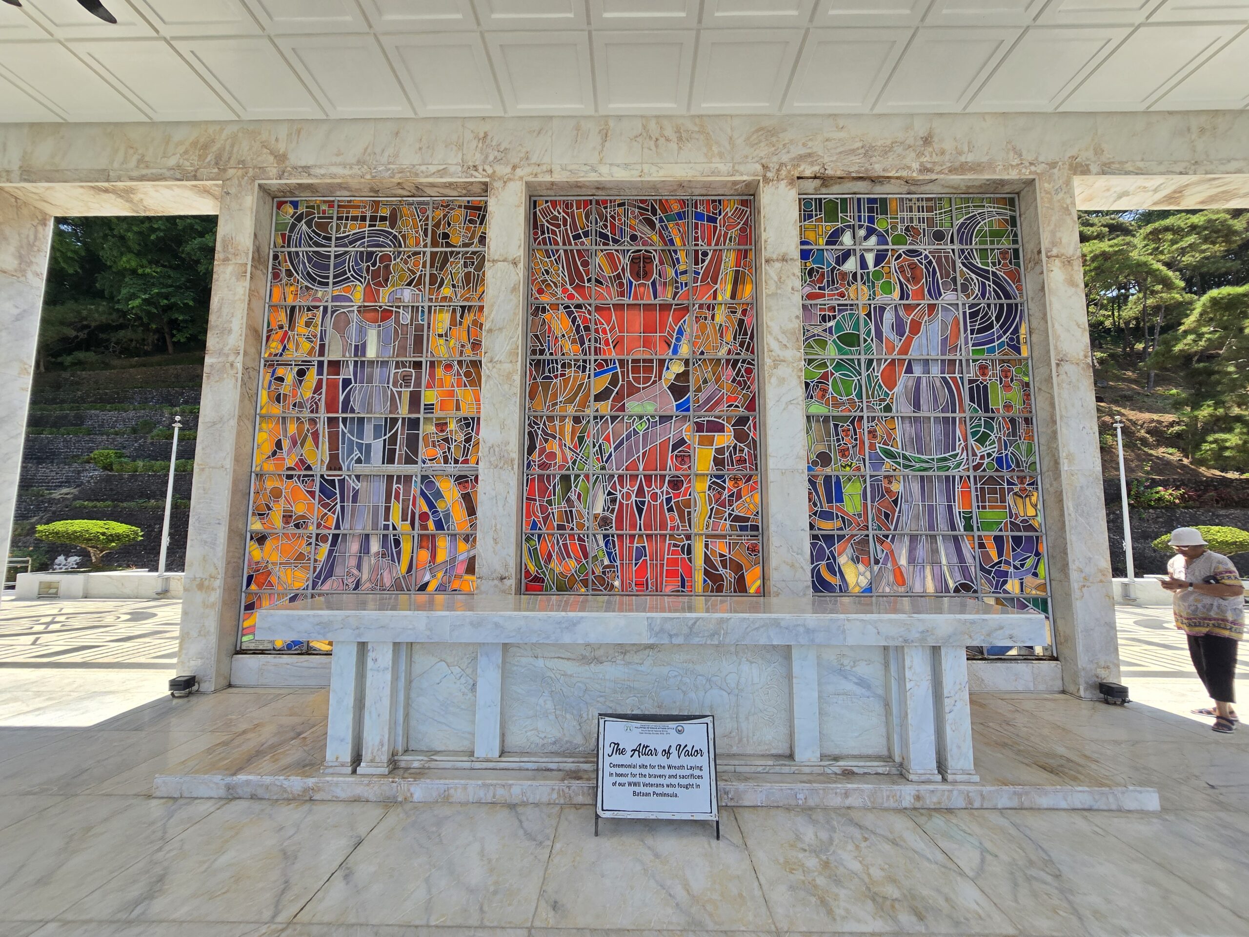
The lateral interior walls of the Colonnade feature an extensive marble inscription narrating the Battle of Bataan. The text explicitly frames the conflict as a unifying national epic, reading in part: “On this ground gallant men chose to die rather than surrender… fighting valiantly, the United States Army Forces in the Far East (USAFFE) led by General Douglas MacArthur was thrown back in fierce actions by the implacable advance of the enemy”.12 The narrative text concludes with a clear directive to future generations: “Our mission is to remember”.12
Furthermore, the architectural perimeter honors the specific military units that fought in the campaign. The Colonnade features 18 bronze insignias representing the various USAFFE divisions and units, executed by the prominent talleres (workshops) of Maximo Vicente, Leonides Valdez, and Angel Sampra and Sons.24 Each bronze insignia is accompanied by a flagstaff intended to bear the colors of the respective division, ensuring that the distinct organizational elements of the defense are permanently and individually recognized within the broader national monument.5
7. The Sculptural Iconography of Napoleon Abueva
The visual and thematic weight of the Mount Samat National Shrine relies heavily on the sculptural contributions of Napoleon V. Abueva. Appointed to the project in his late thirties, Abueva utilized a modernist approach characterized by robust, monumental forms that projected strength, suffering, and resilience.18 His work at the shrine is divided into two major installations: the high reliefs of the Colonnade and the bas-reliefs at the base of the Memorial Cross.
The Colonnade High Reliefs
The outer parapets of the Colonnade are clad in 19 distinct high-relief marble sculptures crafted by Abueva.1 These panels provide a sequential, visual narrative of the Philippine experience during World War II, alternating chronologically and spatially with the USAFFE bronze insignias. The reliefs vividly depict scenes of national mobilization (inscribed with themes such as “All responded to the Colors”), the second inauguration of President Manuel L. Quezon on Corregidor, the brutal realities of the battlefield, the ultimate surrender, and the agonies of the Bataan Death March.13 By utilizing direct carving techniques on marble—a physically demanding process that Abueva mastered—he captured the visceral tension of the conflict, elevating the historical events to the status of a national mythos.18
“Nabiag nga Bato” (Living Stone)
At the terminus of the 14-flight zigzagging footpath lies the 11-meter-high base of the Memorial Cross, which is entirely encased in a separate series of sculptural slabs titled Nabiag nga Bato, an Ilocano phrase translating to “Living Stone”.16
While the Colonnade reliefs focus strictly on the events of World War II, the Nabiag nga Bato expands the historical lens considerably. Abueva designed these bas-reliefs to anchor the courage of the Bataan defenders within a longer, unbroken continuum of Philippine resistance against foreign domination.17 The panels feature monumental depictions of pre-colonial and revolutionary figures, including Lapu-Lapu at the Battle of Mactan in 1521, the execution of national hero Dr. Jose Rizal by Spanish authorities, and the martial leadership of General Antonio Luna during the Philippine-American War.17 This deliberate thematic choice by Abueva and Castillo serves to contextualize the Fall of Bataan not as an isolated 20th-century defeat, but as the latest chapter in an ongoing, centuries-long struggle for Philippine sovereignty.17
8. The Memorial Cross: Dimensions and Geographic Dominance
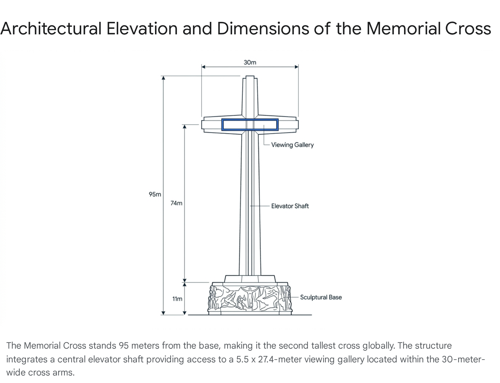
Rising directly behind the Colonnade at the absolute peak of the mountain is the Memorial Cross, the visual hallmark of the shrine. It is widely recognized as the second tallest cross in the world, surpassed only by the monumental cross at the Valle de los Caídos (Valley of the Fallen) in El Escorial, Spain.4
The structural specifications of the cross underline its engineering complexity and scale. Constructed of structural steel and reinforced concrete, the monument stands 95 meters (312 feet) tall from its base, though some early historical markers and documentation occasionally round this to 92 meters.1 The cross arms intersect the vertical shaft at a height of 74 meters (243 feet).4 The massive arms extend a total of 30 meters (98 feet) across, with each wing measuring 15 meters on either side of the central shaft.4
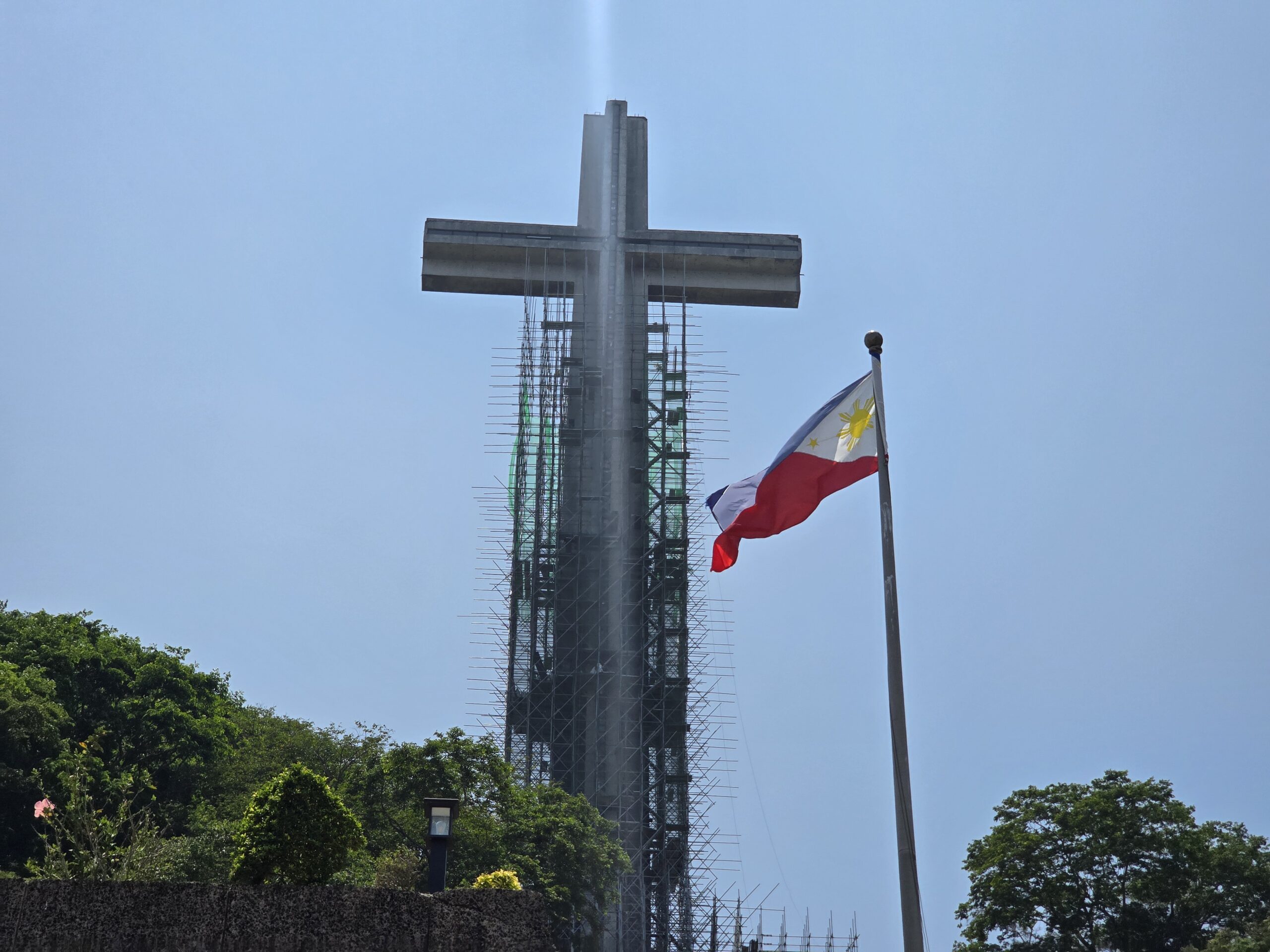
The exterior finish of the cross above the 11-meter sculptural base consists of chipped granolithic marble.6 This material choice ensures the cross reflects sunlight brilliantly, maximizing its visibility as a stark white contrast against the dense green canopy of the Bataan peninsula.29
Internally, the vertical steel shaft houses an elevator system designed to transport visitors to the viewing gallery located inside the transverse arms of the cross.1 The gallery measures 5.5 meters by 27.4 meters (18 by 90 feet) and features a vertical clearance of 2.1 meters (6.9 feet).4 From this elevated vantage point, visitors are offered a 360-degree panoramic view that encompasses the entirety of the Bataan Peninsula, the Corregidor Island fortress, the West Philippine Sea, and, under clear atmospheric conditions, the skyline of Manila located approximately 50 kilometers across the bay.1 For times when the elevator is non-operational for maintenance, a concrete staircase is built into the structure, ensuring access to the gallery wings.28
9. Subterranean World War II Museum and Artillery Artifacts
Integrated seamlessly into the complex is a subterranean World War II museum, positioned beneath the esplanade of the Colonnade. This underground placement ensures that the museum facility does not disrupt the visual primacy of the open-air altar or the Memorial Cross above.32 Recently modernized with a P19 million funding allocation, the facility has been formally renamed the “Bataan World War II Museum and the Legacy of Bataan and its Heroes”.33
The museum functions as the primary repository for artifacts and tactical narratives of the Battle of Bataan. Exhibits house a substantial collection of wartime memorabilia, including salvaged weaponry, military uniforms, and tactical accoutrements utilized by the Philippine Commonwealth Army, the American forces, and the Japanese Imperial Army.7 A central educational feature of the museum is a large-scale diorama detailing the tactical dispositions and the rugged terrain over which the Battle of Bataan was fought, utilizing blue LEDs to indicate Allied positions and red LEDs for Japanese forces.34
The museum’s upper floor and subterranean walls are lined with a gallery of portraits and photographs honoring prominent Allied leaders, Medal of Honor recipients, and guerrilla commanders who directed operations during the invasion and subsequent occupation. The inclusion of diverse units ensures a comprehensive representation of the varied forces that contested the peninsula.34
Table 2: Selected Hero Portraits and Units Recognized in the Museum
| Recognized Individual / Leader | Key Affiliated Units Highlighted in the Shrine |
| Bernard Lawrence Anderson | 81st Philippine Infantry Division |
| Willibald Charles Bianchi | Philippine Scouts |
| Donald Dunwody Blackburn | Philippine Army |
| Jose Cabalfin Calugas | United States Army Forces in the Far East (USAFFE) |
| Vicente Lim | United States Marine Corps |
| Alexander Ramsey Nininger | US Army Air Corps |
| Russell William Volckmann | Filipino-American Irregular Troops / Guerrillas |
| (Source: Museum monument text and archival data 34) |
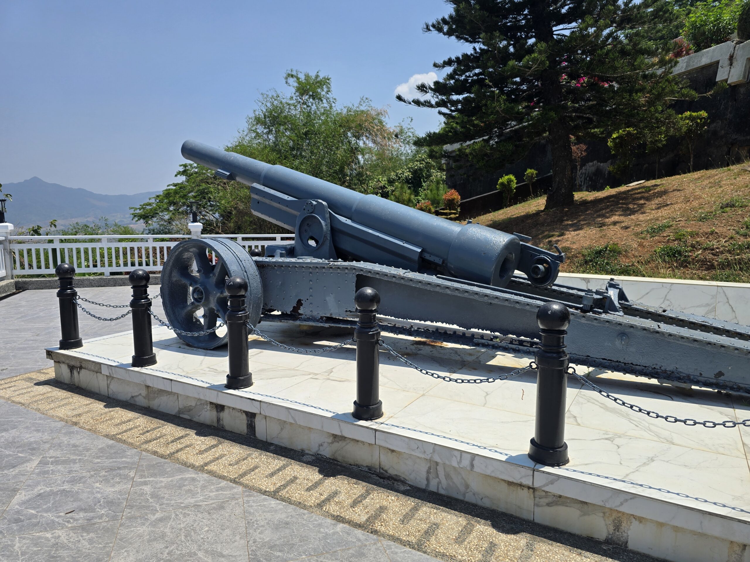
Above ground, positioned near the entrance to the building, rests a significant piece of preserved military hardware: a 155mm GPF (Grand Puissance Filloux) Towed Howitzer.7 This specific artillery piece represents the heavy guns utilized by the USAFFE to hold the Orion-Bagac line.36 Historical accounts indicate that as Bataan fell on April 9, 1942, American officers such as Captain D’Arezzo received orders to destroy their guns to prevent Japanese capture. After TNT charges failed to destroy the weapon, crews resorted to loading a round in the chamber with a 1.5x powder charge, stuffing the barrel with rocks and sand, draining the recoil cylinders of oil, and firing the gun with a long lanyard to intentionally destroy the breech.35 The presence of the 155mm GPF serves as a tangible artifact of the desperate doctrine of material denial executed during the final hours of the campaign.
10. Dedication, Memorialization, and the Day of Valor Protocols
Although the cornerstone was laid in 1966, the completed Dambana ng Kagitingan was officially inaugurated in 1970 to coincide with the 25th anniversary of the end of World War II.1 The inauguration served a dual purpose for the Marcos administration: honoring the veterans while simultaneously utilizing the monument to project national resilience and political alignment with anti-communist allies during the height of the Cold War.37 In his speeches during this era, Marcos leveraged the imagery of Bataan to rally against “alien ideologies” and frame his administration’s development goals as a continuation of the wartime struggle for freedom.37
Operationally, the shrine is the focal point for the annual national observance of Araw ng Kagitingan (Day of Valor), a public holiday held every April 9 to mark the fall of Bataan.38 During this solemn observance, protocol dictates that the President of the Philippines, alongside top military brass, foreign dignitaries, and surviving veterans or their descendants, gather at the Colonnade for a wreath-laying ceremony.37
Recent ceremonies have highlighted the enduring international significance of the site. During the 82nd and 83rd observances in 2024 and 2025, President Ferdinand R. Marcos Jr. led the ceremonies, emphasizing that the heroism of Bataan transcends mere observance by law and serves as the foundation for a united Filipino people.40 These events are heavily attended by the diplomatic corps, prominently including the Ambassadors of Japan and the United States (such as Japanese Ambassador Endo Kazuya and US Chargé d’Affaires Robert Ewing), reflecting a modern narrative of post-war reconciliation and enduring alliances.39 For the Japanese delegation, attendance at Mount Samat often involves expressions of regret and a commitment to peace, linking former adversaries in a shared commemorative space.37
Maintenance and preservation have been ongoing challenges, as the harsh mountain climate continuously degrades the infrastructure.28 In a push to revitalize the monument’s visibility, a major aesthetic lighting project was completed in May 2023. Managed through TIEZA, linear lighting and aesthetic fixtures were installed to illuminate the Memorial Cross and Colonnade. This project made the structure highly visible at night across Manila Bay for the first time since its construction, a feature intended to jumpstart nighttime tourism operations after the lull of the COVID-19 pandemic.30
11. Modern Evolution: The Flagship Tourism Enterprise Zone (FTEZ)
The management of the Mount Samat National Shrine relies on a strategic collaborative agreement between the Department of National Defense-Philippine Veterans Affairs Office (DND-PVAO) and the Tourism Infrastructure and Enterprise Zone Authority (TIEZA).9 Under this framework, PVAO is mandated to maintain the solemnity of the site, manage the museum operations, and advocate for veterans’ interests, while TIEZA is responsible for broad-scale tourism development, infrastructure upgrades, and the provision of investment incentives.9
In October 2017, to ensure the long-term economic sustainability of the shrine, the TIEZA Board approved the Mount Samat Comprehensive Tourism Master Plan (CTMP), officially designating the area as a Flagship Tourism Enterprise Zone (FTEZ).3 The master plan aims to transition the site from a purely passive memorial, heavily reliant on government subsidies, into an active, multi-functional, and self-sustaining heritage destination.3
The FTEZ master plan divides the territory into three primary functional areas:
- The Shrine Site (75 Hectares): Serving as the “heritage core,” this area includes the Memorial Cross and Colonnade. Phase 1 development focused on immediate repairs, such as upgrading the cross’s elevator. Phase 2 plans include the construction of a Center for World War II Studies, a new administration office, and a Tribute Wall.3
- The Locator Site (144 Hectares): Positioned on the western fringe of the FTEZ, this zone acts as the economic engine. It is designated for public-private partnerships (PPP) and is subdivided into a 24.5-hectare Agro-Residential Zone (for agri-tourism and wellness centers), a 15-hectare Commercial Zone, and a 33-hectare Leisure and Recreational area intended for boutique hotels and entertainment.3
- The Forest Reserve (879 Hectares): Acting as the environmental connector, this zone restricts development to low-impact activities.3
Table 3: Mount Samat FTEZ Land Allocation
| Zone Designation | Area | Primary Function / Planned Infrastructure |
| Shrine Site | 75 ha | Heritage Core: Memorial Cross, Colonnade, WWII Museum, Tribute Wall |
| Locator Site | 144 ha | Economic Hub: Boutique Hotels, Commercial Centers, Agri-tourism, Transport Hub |
| Forest Reserve | 879 ha | Environmental Buffer: Forest protection, eco-trails, canopy walks |
| (Source: Extracted from the Mount Samat CTMP 3) |
The most significant recent infrastructure advancement under this master plan is the P170-million Visitors Complex. Groundbreaking for the complex occurred on April 9, 2024, with target completion set for mid-2025 or 2026, potentially aligning with Independence Day celebrations.43 Designed to stimulate local enterprises and generate employment, the complex features three main facilities: a Tourist Assistance Center, a modern Visitors Center with orientation and exhibit spaces, and a Multipurpose Administration Building.8 Future phases of the transportation overlay also propose the installation of a cable car system to link the Locator Site’s transport hub to the Shrine Site, further reducing vehicular impact on the historic core.3
12. Environmental Context and Structural Resilience
The physical placement of the Mount Samat National Shrine demands rigorous environmental management and continuous structural oversight. Geologically, Mount Samat is classified as an extinct parasitic cone of the larger Mount Mariveles volcano.2 The massive Memorial Cross is situated perilously close to the edge of the mountain’s 550-meter-wide crater rim.2
This elevated topography exposes the towering 95-meter concrete and steel cross to extreme wind velocities, particularly during the Philippine typhoon season. Furthermore, the Bataan peninsula’s proximity to active fault lines within the Western Bataan Lineament requires high structural resilience. Independent civil engineering studies, including assessments simulating a magnitude 6.0 earthquake, have been conducted to rigorously evaluate the ongoing performance and structural integrity of the aging cross.20 Maintaining this resilience requires continuous monitoring by PVAO and TIEZA engineers to prevent the degradation of the granolithic marble facade and the internal steel framework from water ingress and sheer stress.20
Simultaneously, the 879-hectare forest reserve surrounding the shrine acts as a vital carbon sink and ecological buffer. The management strategy strictly delineates “Forest Protection” areas from “Forest Use” areas.3 Permitted activities are limited to low-impact eco-tourism, such as bird-watching, canopy walks, and geocaching (GPS-based treasure hunting).3 This zoning ensures that the surge in heritage tourism and the commercial development generated by the FTEZ locator sites do not compromise the biodiversity and ecological stability of the Bataan peninsula.
13. Strategic Summary and Future Trajectory
The Mount Samat National Shrine represents a masterclass in the architectural codification of history. By transforming the site of a devastating tactical military defeat into a monumental tribute to valor, the architects, sculptors, and planners successfully cemented the Battle of Bataan into the physical and cultural landscape of the Philippines. Napoleon Abueva’s Nabiag nga Bato and Colonnade reliefs effectively synthesize the events of World War II within the broader sweep of Philippine resistance against colonial and imperial powers, while the sheer scale of Lorenzo del Castillo’s Memorial Cross anchors the narrative geographically across Manila Bay.
Today, the Dambana ng Kagitingan is navigating a critical transition. Through the strategic implementation of the TIEZA Flagship Tourism Enterprise Zone master plan, the site is evolving from a static memorial into a self-sustaining heritage tourism ecosystem. The addition of the P170-million Visitors Complex, the modernization of the subterranean museum, and the planned commercial locator zones demonstrate an operational pivot toward immersive historical education and economic integration. Ultimately, the meticulous maintenance of the shrine’s structural integrity, combined with progressive economic master planning, ensures that the sacrifices made on the slopes of Mount Samat will remain a dominant fixture—both literally and historiographically—for future generations.
We visisted the site on April 23, 2026, and the photos were taken then by the author. Both the cross and museum were closed for renovation. Renovation is estimated to complete in 2027.
Please share the link on Facebook, Forums, with colleagues, etc. Your support is much appreciated and if you have any feedback, please email us in**@*********ps.com. If you’d like to request a report or order a reprint, please click here for the corresponding page to open in new tab.
Sources Used
- Mount Samat National Shrine – Wikipedia, accessed April 24, 2026, https://en.wikipedia.org/wiki/Mount_Samat_National_Shrine
- Mount Samat – Wikipedia, accessed April 24, 2026, https://en.wikipedia.org/wiki/Mount_Samat
- The Proposed Redevelopment of the Mt. Samat Shrine of Valor: Balancing Heritage, Progress and Sustainability, accessed April 24, 2026, https://capu.arcabc.ca/_flysystem/repo-bin/2021-11/capu_5697.pdf
- Mt. Samat National Shrine – Bataan.gov.ph, accessed April 24, 2026, https://bataan.gov.ph/behold-bataan/mt-samat-national-shrine/
- The Rising of the Shrine [Construction Details Part 1] | RISE OF THE FALLEN, accessed April 24, 2026, https://dambanangkagitingan.wordpress.com/2011/11/12/the-rising-of-the-shrine-construction-details-part-2/
- RISE OF THE FALLEN | Doon po sa amin, matayog ang diwa ng huling tanggulan, accessed April 24, 2026, https://dambanangkagitingan.wordpress.com/
- MT. SAMAT SHRINE OF VALOR: Remembering the brave and the fallen – Issuu, accessed April 24, 2026, https://issuu.com/gadgetsmagazine/docs/2019_04_april/s/10416675
- Mt. Samat visitors complex to create jobs, enhance heritage tourism in Bataan, accessed April 24, 2026, https://pia.gov.ph/news/luzon/cl/mt-samat-visitors-complex-to-create-jobs-enhance-heritage-tourism-in-bataan/
- TIEZA-DND MoA for Mt. Samat TEZ | PDF | Regulatory Compliance | License – Scribd, accessed April 24, 2026, https://www.scribd.com/document/399604975/Draft-Moa-y-Pvao
- World War II in the Philippines | The National WWII Museum | New Orleans, accessed April 24, 2026, https://www.nationalww2museum.org/events/educational-travel/world-war-ii-philippines/world-war-ii-philippines-march-16-24-2024
- Bataan battlefield visit | WWII Forums, accessed April 24, 2026, http://ww2f.com/threads/bataan-battlefield-visit.13829/
- Mt. Samat Colonnade – Monument Details, accessed April 24, 2026, https://www.uswarmemorials.org/html/monument_details.php?SiteID=2569&MemID=3355
- Dambana ng Kagitingan (Mount Samat Shrine), Pilar, Bataan – The Quaint Traveler, accessed April 24, 2026, http://thequainttraveler.blogspot.com/2014/07/DambanaNgKagitinganMountSamatShrineBataan.html
- Proclamation No. 103 – Lawphil, accessed April 24, 2026, https://lawphil.net/executive/proc/proc1966/proc_103_1966.html
- MT. SAMAT NATIONAL SHRINE | Senate of the Philippines Legislative Reference Bureau, accessed April 24, 2026, https://ldr.senate.gov.ph/subject/mt-samat-national-shrine
- Bataan: History, Culture, and Geography | PDF | Military | Violence – Scribd, accessed April 24, 2026, https://www.scribd.com/document/360382908/Bataan
- The Politics of Asia-Pacific War Memorialization in Thailand’s Victory Monument and the Philippines’ Shrine of Valor – Japan Focus, accessed April 24, 2026, https://apjjf.org/2023/10/candelaria
- ABUEVA Works and Words – Artes De Las Filipinas, accessed April 24, 2026, https://artesdelasfilipinas.com/archives/abueva-works-and-words/
- Birth Anniversary of Napoleon Abueva – National Museum, accessed April 24, 2026, https://www.nationalmuseum.gov.ph/2022/01/26/birth-anniversary-of-napoleon-abueva/
- assessing the performance of a heritage structure in bataan under a magnitude 6.0 earthquake: mount samat memorial cross – ResearchGate, accessed April 24, 2026, https://www.researchgate.net/publication/341639063_ASSESSING_THE_PERFORMANCE_OF_A_HERITAGE_STRUCTURE_IN_BATAAN_UNDER_A_MAGNITUDE_60_EARTHQUAKE_MOUNT_SAMAT_MEMORIAL_CROSS
- DAMBANA NG KAGITINGAN ATOP MT. SAMAT – www.dwaentertainment.com, accessed April 24, 2026, https://dwaentertainment.com/2018/04/09/dambana-ng-kagitingan/
- MOUNT SAMAT HONORS THE VALOR OF BATAAN – Meandering through the Prologue, accessed April 24, 2026, https://meaderingthroughtheprologue.com/mount-samat-honors-the-valor-of-bataan/
- Information about Mount Samat War Memorial | Guide to the Philippines, accessed April 24, 2026, https://guidetothephilippines.ph/destinations-and-attractions/mount-samat-war-memorial
- Dambana ng kagitingan | DOCX – Slideshare, accessed April 24, 2026, https://www.slideshare.net/slideshow/dambana-ng-kagitingan/30746747
- Mount Samat National Shrine: A castle on the hill – CJ LAO – WordPress.com, accessed April 24, 2026, https://cleiffordjourney.wordpress.com/2017/03/20/mount-samat-national-shrine/
- Sculpting heaven – Philippines Graphic, accessed April 24, 2026, https://philippinesgraphic.com.ph/2018/03/03/sculpting-heaven/
- Top 14 Tourist Spots in Bataan: Home to Historical and Nature Spots Near Manila, accessed April 24, 2026, https://guidetothephilippines.ph/articles/what-to-experience/bataan-tourist-spots
- Mt. Samat, Bataan – SunStar, accessed April 24, 2026, https://www.sunstar.com.ph/baguio/lifestyle/mt-samat-bataan
- Top 10 Intriguing Facts About Shrine of Valor – Discover Walks Blog, accessed April 24, 2026, https://www.discoverwalks.com/blog/philippines/top-10-intriguing-facts-about-shrine-of-valor/
- From One Marcos to Another Marcos: Towering Heroism and Hope at the Dambana ng Kagitingan – People’s Television Network, accessed April 24, 2026, https://ptni.gov.ph/from-one-marcos-to-another-marcos-towering-heroism-and-hope-at-the-dambana-ng-kagitingan/
- Dambana ng Kagitingan (Shrine of Valor): Mount Samat, Bataan – Travel Through Paradise, accessed April 24, 2026, https://travelthroughparadise.com/destinations/articles/Pilar_Mt_Samat_And_Dambana_Ng_Kagitingan_Shrine_Of_Valor.php
- World War Two Museum on Mt. Samat (proposed) – Dominic Galicia, accessed April 24, 2026, http://www.domgalicia.com/2020/08/world-war-two-museum-on-mt-samat.html
- Mt. Samat Underground Museum reopens after modernization – The Voice Newsweekly, accessed April 24, 2026, https://thevoicenewsweekly.com/%F0%9D%90%8C%F0%9D%90%AD-%F0%9D%90%92%F0%9D%90%9A%F0%9D%90%A6%F0%9D%90%9A%F0%9D%90%AD-%F0%9D%90%94%F0%9D%90%A7%F0%9D%90%9D%F0%9D%90%9E%F0%9D%90%AB%F0%9D%90%A0%F0%9D%90%AB%F0%9D%90%A8%F0%9D%90%AE/
- Mt. Samat Museum – Monument Details, accessed April 24, 2026, https://www.uswarmemorials.org/html/monument_details.php?SiteID=2569&MemID=3364
- ShellWings, accessed April 24, 2026, https://shellwings.wordpress.com/
- TEXT For Philippine Scouts Flier – Squarespace, accessed April 24, 2026, https://static1.squarespace.com/static/5e10ea57f51cd16ca72b46b4/t/5e85e6c4d3eee631a4d020c4/1585833683026/Heritage_of_Valor.pdf
- TRANSNATIONAL BATAAN MEMORIES: TEXT, FILM, MONUMENT, AND COMMEMORATION A DISSERTATION SUBMITTED TO THE GRADUATE DIVISION OF THE – ScholarSpace, accessed April 24, 2026, https://scholarspace.manoa.hawaii.edu/server/api/core/bitstreams/ed5b2627-59a0-4f6e-a118-3bdd67e47650/content
- Day of Valor – Wikipedia, accessed April 24, 2026, https://en.wikipedia.org/wiki/Day_of_Valor
- Visitors Complex to rise at Mt. Samat National Shrine – Bataan.gov.ph, accessed April 24, 2026, https://bataan.gov.ph/news/visitors-complex-to-rise-at-mt-samat-national-shrine/
- 82nd Anniversary of the Araw ng Kagitingan 04/09/2024 – YouTube, accessed April 24, 2026, https://www.youtube.com/watch?v=vTiiqTKU3_E
- Viewing of the Newly Curated Mt. Samat National Shrine Underground Museum 4/9/2025, accessed April 24, 2026, https://www.youtube.com/watch?v=Z51aDGKGnvA
- Mt. Samat Development Plan 2025 | PDF | Economies – Scribd, accessed April 24, 2026, https://www.scribd.com/document/528212664/Mt-Samat-Bataan-briefer
- Mt. Samat visitors complex to create jobs, enhance heritage tourism in Bataan – Punto! Central Luzon, accessed April 24, 2026, https://punto.com.ph/mt-samat-visitors-complex-to-create-jobs-enhance-heritage-tourism-in-bataan/
- Mt. Samat visitors complex to enhance tourism in Bataan – SunStar, accessed April 24, 2026, https://www.sunstar.com.ph/pampanga/mt-samat-visitors-complex-to-enhance-tourism-in-bataan
- P170M visitors’ complex to rise soon in Mt. Samat | The Manila Times, accessed April 24, 2026, https://www.manilatimes.net/2026/04/15/regions/p170m-visitors-complex-to-rise-soon-in-mt-samat/2319855